Last month I decided to visit the location. I have to admit that I was not expecting much, based on my background research. That is what I found: no historical plaque celebrating the finding of the Humpback whale, no train station, no train tracks, and little evidence that a gravel pit was close to the abandoned rail line. I suspect that over time most of the gravel and sand was dug up and taken away.
I should note that Dawson misspelt the location: it is Welsh’s Station, rather than Welshe’s (and certainly not Walsh Station as shown on the current official plan for Montague Township).
Welsh’s Station is shown on the following extract that I’ve taken from a map of Montague Township that appeared in the Illustrated Atlas of Lanark County (maps from surveys under the direction of H.F. Walling, Published by D. P. Putnam, Prescott, Canada West, 1868).

Illustrated Atlas of Lanark County, 1880; H. Belden & Co., Toronto.
http://digital.library.mcgill.ca/countyatlas/searchmapframes.php
Numogate, which appears on the map, still exists. The road that runs from Smith’s Falls through Numogate is now Highway 15. The road just south of Welsh’s Station, between Concession VII and Concession VIII is now called Ferguson Tetlock Road. The railroad line identified on this extract as the Main Line of the Canada Central Railway, had become a line of C. P. Railway when Professor Dawson penned his article on the finding of the humpback whale. Regrettably, the tracks have been torn up. However, the track ballast identifies where the rail line used to run.
The following is an extract from the map that is Schedule A to the Official Plan of the Township of Montague.

This extract provides the current names of the roads, shows the abandoned line of the Canadian Pacific Railway, misspells Welsh’s Station as Walsh Station, and shows a sand and gravel pit (marked with a “P”) off highway 15 just south of Numogate. I visited that sand and gravel pit. It appears to have been abandoned many years ago, and little if any sand or gravel is left to be taken from the pit. Below is a photograph of the pit.

Dr. A. P. Coleman of the Ontario Bureau of Mines, and a professor of geology at the University of Toronto, visited the location in 1901. He found more than I did. Here is his description:
“The finding of bones of a whale near Smith's Falls in 1882 attracted much attention at the time. The bones, which were sent to Sir William Dawson and are now in the Peter Redpath museum at Montreal, consist of two vertebrae and a rib, the largest vertebra 11 inches in diameter and 7 inches in length ; the other 10 by 4. It has been determined as Megaptera longimana, a species still common in the gulf of St. Lawrence and sometimes ranging some distance up the river. The bones are in good preservation, but white and brittle from the loss of organic matter. Associated with them were shells of Macoma fragilis, a species common in the Saxicava sand. The find was made in a C. P. R. gravel pit at Welch's, three miles north of Smith's Falls, and, according to the railway levels, at a height of 440 feet above the sea. ...
At present the gravel pit at Welch's shows a face of 52 feet consisting of coarse sand and gravel with many larger stones, the latter generally subangular or only partially rounded. Since the gravel pit has not been in use for some years the stratification is not well seen, sand having run down from above. No shells were found, but this was to be expected, since they tend to crumble when long exposed to the weather. The sand and gravel have not the look of the Saxicava sand near Ottawa, but are much coarser and less perfectly stratified; nor do they seem to have been formed on a beach. They run as a ridge having a general direction about 15 degrees east of north, not far from the same as the striae shown on well polished Potsdam sandstone a few hundred yards to the west, where 12 degrees east of north was observed. The gravel ridge has somewhat the look of a moraine and includes a shallow kettle hole with no outlet, just to the east of the highest part. The deposit seems to be a kame rather than a beach, the many large subangular boulders suggesting ice action. The ridge is not long enough or distinct enough to be an esker.
The bones are said to have occurred 30 feet below the surface of the gravel, but apparently the carcass of the whale was enclosed in a beach deposit formed against the flank of the ridge in post-glacial times. As the level of the track at Welch's is 431 feet above sea, and the gravel rises at its highest part 52 feet higher as determined by hand levels the summit of the ridge is 483 feet above the sea. but the old beach probably 40 feet lower.”
A. P. Coleman, 1901, Sea Beaches of Eastern Ontario, Report of the Bureau of Mines, 1901, Province of Ontario, pages 215-227 at pages 216 and 2017.
The sand and gravel pit may also have been described by A. Ledoux of the Ontario Bureau of Mines in 1918, as follows:
“There is some gravel near Smiths Falls which was extensively used by the railway companies as ballast.... The gravel pit owned by George Kerfoot, Smiths Falls, is in the township of Montague, lot 26, concession 8. It is about 3.5 miles north of Smiths Falls, near the tracks of the Canadian Pacific railway. The average dept of the pit is 10 feet, below which clay is found. The material is about two parts of gravel to one of sand... There is an estimated reserve of three acres.”
A. Ledoux, 1918, Sand and Gravel in Ontario, Report of the Bureau of Mines, 1918, Province of Ontario, at page 61.
Two years ago Victoria Lee of the Ontario Geological Survey issued a report on the aggregate resources of Lanark County that included the gravel pits in the Township of Montague. She discounts the Township of Montague as a significant source for sand and gravel, but does list eight licensed pits in the Township of Montague, including the pit south of Numogate, which is identified as pit 133 in her report and on her maps. She describes the pit as covering 16.6 hectares, with a face height of 2-6 meters, with 20 -30 percent gravel and mentions that the “Pit has been developed in an ice-contact deposit.” Below is part of her map showing the location of the licensed pit. Interestingly, she shows two sand and gravel deposits close to what was Welsh’s Station: the first south of Numogate and the second northwest of Numogate.
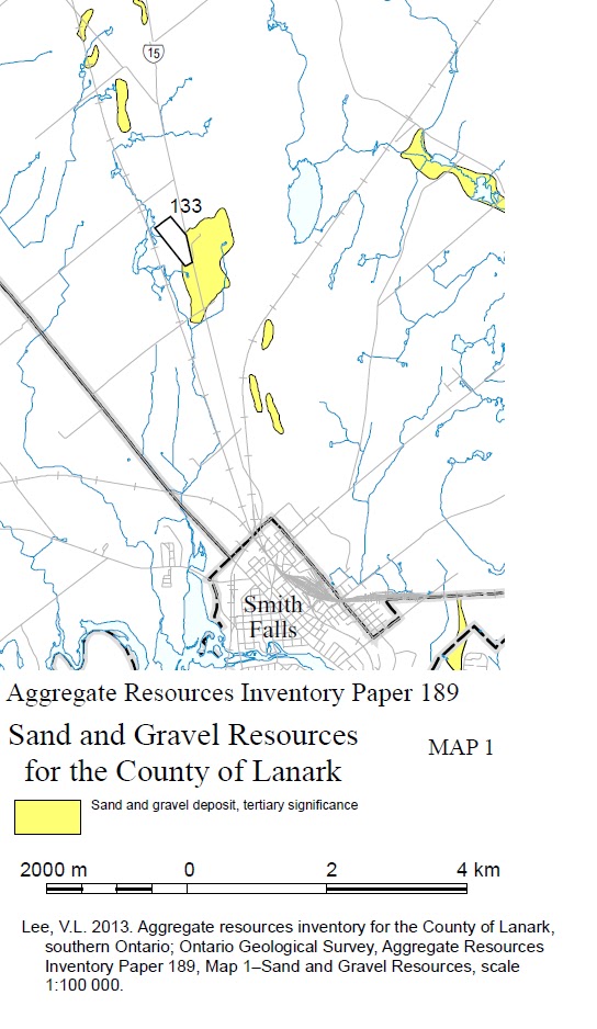
(Victoria L. Lee, 2013, Aggregate resources inventory of the County of Lanark, southern Ontario: Ontario Geological Survey, Aggregate Resources Inventory Paper 189, 85 p.
Her report can be downloaded from:
http://www.geologyontario.mndmf.gov.on.ca/mndmfiles/pub/data/imaging/ARIP189/ARIP189.pdf )
Map P2622 published three decades earlier by the Ontario Geological Survey shows four pits south of Numogate, including one to the north of Victoria Lee’s Licensed Pit 133 and just south of Ferguson Tetlock Road. I did not find that pit.

G.A. Gorrell ;S. Margeson ;J. Lindablom ;R. Trotter, 1985, Sand and gravel assessment, Lanark County, south half, Map P2622
URL: http://www.geologyontario.mndmf.gov.on.ca/mndmfiles/pub/data/imaging/P2622/P2622.pdf
Christopher Brett
Perth, Ontario
No comments:
Post a Comment