Monday 26 October 2015

A Good Year to Look at the Stromatolites along the Ottawa River - Part 2, near Dunrobin

The water level of the Ottawa River is still low.  As a consequence outcrops that form the river bed are visible and accessible.   Below are photographs that I took a few days ago of the domal stromatolites that outcrop in the bed of the Ottawa River near Dunrobin, just downstream from the  Port of Call Marina.


The blue ruler in the photos is 12 inches (30 cm) long.

A map showing the location of the marina can be found at Port of Call Marina’s web site:  www.portofcall.ca

Christopher Brett
Perth, Ontario

Thursday 22 October 2015

Soft-Sediment Deformation (Seismites) in Nepean Sandstone Close to the Rideau Lake Fault

Soft-sediment deformation structures are deformations that occur in sediments that have not undergone lithification before the deformation structures form.  They are the result of liquefaction or fluidization in water-saturated unconsolidated sediments.  Liquefaction or fluidization may be caused by various  processes.  Soft-sediment deformation structures related to seismically induced liquefaction or fluidization are named seismites.

Below are photographs that I took over two years ago of an outcrop of Nepean sandstone that I found in June, 2013  that is less than a kilometer southwest of the lock at The Narrows on the Rideau Canal.


The pen in the first photo is about 15 cm long.

The photographs show deformed beds of Nepean Sandstone that occur above flat lying beds of sandstone and below flat lying beds of sandstone.   These deformed beds are also less than a kilometer south of the Rideau Lakes Fault that was identified by Wynne-Edwards (1967).  I believe the deformed beds in the Nepean sandstone to be seismites that could have resulted from movement along the Rideau Lakes Fault, which suggests that the fault was active in the Cambrian.    Below is an extract from Wynne-Edwards’ map of the Westport area showing the location of the outcrop that I photographed in relation to the Rideau Lakes Fault.


Wynne-Edwards (1967) identified the Rideau Lakes Fault as a major structural feature at least 100 miles (160 kilometers) long.  He mentions that “there is abundant evidence that the shear zone represents a Precambrian wrench fault of major proportions. ... Although post-Ordovician movement can be demonstrated in several places, evidence that the Rideau Lakes fault originated before the deposition of these sediments in abundant.”   As evidence of Precambrian movement he mentions that “On Turnip Island in Rideau Lake, a shear zone 10 feet wide is in the Precambrian rocks beneath the basal Cambro-Ordovician conglomerate, and consists of a soft mass of serpentine and talc separating a sheared quartzo-feldspathic rock from shattered crystalline limestone.”  As evidence of post-Ordovician movement he mentions that “At Narrows Lock, the fault separates Ordovician limestone from Precambrian monzonite, and is marked by a linear gully containing boulders of brecciated limestone.”  As noted above, I believe that the deformed beds that I photographed provide evidence that the fault was also active in the Cambrian (the accepted age of the Nepean formation sandstones) .

A recent paper by Hilbert-Wolf,  Simpson, Simpson, Tindall and Wizevichz (2009) summarized
criteria that permit the interpretation of soft-sediment deformation initiated by seismic activity.  They mention that:

“Generally accepted seismite criteria include: (1) a clear association with potential originating faults, (2) observed deformation that is consistent with seismic origin, (3) a widespread occurrence that is temporally constrained, (4) systematic change in intensity or increase in frequency towards possible epicentre, (5) exclusion of other causal mechanisms, (6) recurrence of deformed horizons over time, (7) underlain and overlain by undisturbed horizons, and (8) faults associated with wedges of interclastic breccias, conglomerates, or massive sandstones. The more criteria that are satisfied the greater the likelihood features are of seismic origin.  In addition, soft-sediment deformation should cross-cut regional and local facies boundaries.”
[Citations Omitted]   

The outcrop that I’ve found meets their first, second, and seventh criteria.


Disruption of Stromatolite Zones in Nepean Sandstone By Seismic Activity


Others have proposed that seismic activity has caused soft-sediment deformation in the Nepean formation sandstone.  In my last posting, on Stromatolites, I mentioned a field trip guide by Donaldson and Chiarenzelli (2004).    For two of their stops they proposed that seismic activity had caused deformation in a stromatolite unit in Nepean sandstone.  Their Stop 7 was at an outcrop of Nepean Formation quartz arenite that displayed cross-sections of random tilted,  laminated, domal stromatolites.  They suggest that “to account for the random tilted arrangement of stromatolites” their model “requires early cementation of the stromatolite unit above a still-unlithified substrate of water charged sand.  As a result of a seismic disturbance, the rigid unit of laterally linked silica-cemented stromatolites snapped apart along the thin inter-stromatolite links, allowing the now-separated heads to rotate and founder in random directions into the overpressurized sand.”
 

Cylindrical structures in Sandstone: A Type of Soft-Sediment Deformation Sometimes Linked to Seismic Activity


A number of my recent postings have been on cylindrical structures in Potsdam Group sandstones.   These cylindrical structures are a type of soft-sediment deformation.    The generally accepted view is that these are dewatering structures resulting from springs.  The leading paper is by Hawley and Hart (1934), who proposed that the cylindrical structures were formed “by circulating waters at some time following the deposition of the sandstone. .. [T]hat following, or throughout, the period of deposition of the sandstone, possibly while it was still submerged, there appeared on top of the sands a series of springs, fed by columns of water rising from an unexposed horizon, such as the basal conglomerate or the underlying pre-Cambrian rocks.   The nature of the adjacent landmass and the structure of the basement rocks... must have controlled the locus of the springs, their rate of flow, and the hydrostatic head.”

Recently Dave Forsyth (2011), when discussing the Cambrian cylindrical structures found in Potsdam (Group) sandstones of southeastern Ontario and northern New York wrote that “The structures are considered to represent the result of vertically upward water flow originating near or at the Grenville basement to produce spring-like conduits of fluidized sand. ... [T]he combination of fluctuating water table, basement relief on the order of 100 meters and well sorted mainly medium to coarse grained quartz grains, enabled the formation of conduit structures of fluidized sand.  The apparent lack of an aquifer cap suggests conduit formation resulted from an unconfined, water table aquifer as opposed to being artesian. ... Changing water table conditions produced a variable internal conduit structure featuring truncated earlier structures and internal concentric annular rings. ”

Intriguingly, many recent papers on cylindrical and conical structures found in sandstone (that is not Potsdam Group sandstone) debate whether the cylindrical and conical structures formed as a result of seismic shock.   For example, see Mathieu, Turner, and Rainbird (2013), who provide a recent review of the issue,  note that the “means by which these cylinders developed is controversial, particularly with respect to the mechanism of fluidization.” and mention that in some studies sediment liquification “was attributed to a seismic event.”   They also note that “It could be argued that multiple seismic events could account for the pulsing flow or the cross-cutting relationships between cylinders.”   However, for their cylinders in Cambrian sandstones on Victoria Island in the Northwest Territories, they reject a seismic trigger and conclude that “the pillar-like structures are attributed to water escape through submarine springs, where groundwater flowing through the karst network emerged onto the Cambrian seafloor.” 

The only publication that I’ve found that suggests that the cylindrical and conical structures in the Potsdam Group sandstones of the Ottawa Embayment may have resulted from seismic activity was by Shrock (1948), who raised the possibility that the cylindrical structures from the Cambrian sandstones found near Kingston may have been formed as a result of seismic shock, but acknowledged that “in reply to a query from the author, Dr. Hawley wrote that he had found no evidence to support” this theory.   Would the answer be different today when geologists are aware that the faults along the St. Lawrence River and along the Ottawa River have been active since the Pre-Cambrian, when seismites have been found in the Nepean Formation close to the Rideau Fault that has been active since the Pre-Cambrian, and when soft-sediment deformation of a stromatolite bed in the Nepean Formation resulted from seismic disturbance?

One feature that may (or may not) lend support to the suggestion that seismic activity initiated  the fluidization that led to the formation of the cylindrical structures is the presence of large numbers of spheroidal concretions in association with a number of the cylindrical columns.  For example,

(A)  Anglin, Boyle and James (1888), which was the first published  report on Canadian cylindrical columns in Potsdam sandstone, mention specimens from the Gildersleeve’s Cataraqui Stone Quarries ten miles from Kingston, and report that Dr. A. R. C. Selwyn, Director of the Geological Survey of Canada “is of opinion that in all probability the columns have been formed by the filling up of what were geyser tubes, or passages for the emission of hot water from some ancient gushing wells like those of Iceland. In association with the columns are found large numbers of roughly spheroidal nodules, or concretionary bodies, also of sandstone, measuring from one to five or six inches in diameter, which to the unscientific mind suggest an idea of fossilized fruit.  It is noticeable that in every case these are marked by an encircling groove.” 

(B)  Franklin Hough (1853), mentions the cylindrical structures in the sandstones at Rossie, New York  and comments “In some places the rock is made up of balls, having a concentric structure like the coats of an onion ... In the vicinity of the iron mines at Rossie, this spheroidal structure is very common and makes up the whole of the rock.  They are of all sizes, from a pen to an orange”

I make the suggestion that the presence of spheroidal concretions might lend support to seismic activity being related to the formation of the cylindrical structures, as there are reports where seismic activity has resulted in soft-sediment deformation structures in the form of balls and pseudo-nodules (for example, Bowman,  Korjenkov, and Porat,  2004).  While I concede that concretions are associated with hot springs and with mineral springs, there is at least one report of “ball-and-pillow” structures in Potsdam sandstones: Salad Hersi and Lavoie (2000) on a stratigraphic section of the Cairnside Formation sandstone (the Quebec equivalent of Ontario’s Nepean Formation sandstone, and New York State’s Keeseville sandstone), show ball-and-pillow structures at three horizons and mention in their report that ball-and-pillow structures “are locally well developed” in the Upper Unit of the Cairnside.  

Christopher Brett
Perth, Ontario

+++++++++++++++++++++++++++++++++++++++++
   
References:

Anglin, T. W., Boyle, D., and James, C.C., 1888
Mineral Exhibit of the Province of Ontario, Descriptive Catalogue, Centennial Exposition of the Ohio and Central States; Cincinnati, July 4 to October 27, 1888, 64 pages  at page 34
https://books.google.ca/books?id=_MdCAQAAMAAJ

Bowman, D.,  Korjenkov, A. and Porat, N., 2004
Late-Pleistocene seismites from Lake Issyk-Kul, the Tien Shan range, Kyrghyzstan;
 Sedimentary Geology 163 (2004) 211–228
 http://activetectonics.la.asu.edu/N_tien_shan/Seismite.pdf

Donaldson, J. Allan  and Chiarenzelli, Jeffrey R., 2004
Stromatolites and Associated Biogenic Structures in Cambrian and Ordovician Strata in and Near Ottawa, Ontario; 76th Annual Meeting, Field Trip Guidebook, New York State Geological Association, 283 pages, at pages 1-20. 

Forsyth, D.A.,  2011,
Evidence and Hypothesis– How the Sandstone Cylinders Formed;
GAC/AGC - MAC/AMC - SEG - SGA  Joint Annual Meeting, Ottawa 2011, Abstracts Volume 34, at page 66    www.mineralogicalassociation.ca/doc/Ottawa2011AbstractsVolume.pdf

Hawley, J. E. and Hart, R. C.,  1934
Cylindrical Structures in Sandstone;
 Bulletin of the Geological Society of America, Volume 45, pages 1017-1034

Hough, Franklin B., 1853
A History of St. Lawrence and Franklin Counties, New York, from the earliest period to the present time; Albany, Little & Co., 708 pages, at page 678.

Hilbert-Wolf, Hannah L.,  Simpson,  Edward L., Simpson, Wendy S., Tindall, Sarah E. and
Wizevichz, Michael C.,  2009,
Insights into syndepositional fault movement in a  foreland basin; trends in seismites of the Upper Cretaceous, Wahweap  Formation, Kaiparowits  Basin, Utah, USA;
Basin Research (2009)   doi: 10.1111/j.1365-2117.2009.00398.x
   
Mathieu, J., Turner, E.C., and Rainbird, R. H., 2013
Sedimentary architecture of a deeply karsted Precambrian-Cambrian unconformity, Victoria Island, Northwest Territories; Geological Survey of Canada, Current Research 2013-1, 15 p.

Salad Hersi, O. and Lavoie, D., 2000
Lithostratigraphic revision of the Upper Cambrian Cairnside Formation, upper Potsdam Group, southwestern Quebec; Geological Survey of Canada, Current Research 2000-D4, 8 pages

Shrock, R.R., 1948
Sequence in Layered Rocks: A Study of Features and Structures Useful for Determining Top and Bottom Order of Succession in Bedded and Tabular Rock Bodies;
McGraw Hill, New York, 507 pages, at pages 136, 220 and 221

Wynne-Edwards, H.R.,  1967,
Map 1182A, Geology, Westport, Ontario; to accompany Memoir 346, Westport Map-Area, Ontario, With Special Emphasis on the Precambrian Rocks, Geological Survey of Canada.

Wynne-Edwards, H.R., 1967,
Westport Map-Area, Ontario, With Special Emphasis on the Precambrian Rocks;
Geological Survey of Canada,  Memoir 346, 146 pages
http://geoscan.nrcan.gc.ca/starweb/geoscan/servlet.starweb?path=geoscan/fulle.web&search1=R=100533


Thursday 1 October 2015

A Good Year to Look at the Stromatolites along the Ottawa River

We were blessed with a fairly dry summer in Eastern Ontario.  As a consequence  the Ottawa River is low and it is a very good year to look at the stromatolites that outcrop along the Ottawa River (which are best viewed when the Ottawa River is low).  The most frequently visited outcrop is likely the one that is in Quebec just across the Champlain Bridge from Ottawa.

Below are photographs that I took two weekends ago on my visit to look at the outcrop.


The outcrop is easy to locate.  Take the first left when you cross the Champlain Bridge, and look on your left for the Champlain Parking Lot about 150 meters from the stoplights.   Then walk about 50 meters back towards the bridge along the bike path.  The outcrop is the river bed.

A little over decade ago J. Allan Donaldson and Jeffrey R. Chiarenzelli provided the following description of the “closely packed domal stromatolites” visible at this outcrop, when describing ‘Stop 4. Stromatolites in Pamelia Formation (Ordovician)’:

“Mapping at 1:25 scale has revealed strong local north-south trends of elongation for the stromatolite heads.  In many places two or more are coalesced in parallel, strings oriented in the same (north-south) direction.   ...these trends are readily attributed to the action of tides and onshore-wind-driven waves .  Some small stromatolites are elongate perpendicular to the prominent north-south trend ...[which] is attributed to longshore currents.   ...  [A] hypersaline environment in which biofilm predators  could not survive is inferred.  This is supported by the observation that, whereas the underlying stromatolite-free beds of carbonate are fossiliferous (with gastropods and vermiform trace fossils particularly abundant), the stromatolite unit is free of megafossils.  Only conodonts have been observed, and those extracted from the stromatolite unit are compatible with a hypersaline environment...”
[Citations omitted]

J. Allan Donaldson and Jeffrey R. Chiarenzelli, 2004a,
Stromatolites and Associated Biogenic Structures in Cambrian and Ordovician Strata in and Near Ottawa, Ontario; 76th Annual Meeting, Field Trip Guidebook, New York State Geological Association, 283 pages, at pages 1-20. 

That field trip guidebook can be downloaded in pdf format from:
http://www.nysga-online.net/    Click on the tab “NYSGA Guidebook Archive”, select “2000s NYSGA Guidebooks” and then select 76th NYSGA 2004.pdf

If you download the guidebook be sure to also look at the following field trip:
J. Allan Donaldson and Jeffrey R. Chiarenzelli, 2004b,
Precambrian Basement and Cambrian-Ordovician Strata , as Displayed in Three Provincial Parks of Canada, 76th Annual Meeting, Field Trip Guidebook, New York State Geological Association, 283 pages, at pages 63-78.       Stop 1 is a visit to Fitzroy Provincial Park to look at the stromatolites while  Stop 3 is a visit to Almonte, Lanark County to look at the stromatolites.


If you are planning to visit  the Champlain Bridge stromatolites I’d recommend that you first visit the following web sites:       

1)    http://http-server.carleton.ca/~jadonald/fieldtrips.html
Ottawa-Gatineau Geological Field Trips, by Professor Allan Donaldson for a course at Carleton University.   This guide contains six stops, including the outcrop of Stromatolites on the Quebec side of the Champlain Bridge.  It includes a map showing the location of stromatolites in relation to the Champlain Bridge, together with two detailed maps of the stromatolites, that I assume is the mapping at 1:25 scale  referred to by Donaldson and Chiarenzelli, 2004a.  (Note that the Blvd. Champlain on Dr. Donaldson’s map is now Blvd. de Lucerne.)
           
2)  http://geo-outaouais.blogspot.ca/2009/11/colonie-de-stromatolites-gatineau.html
This blog posting contains some very good photographs of the outcrop.

3)  http://www.ottawagatineaugeoheritage.ca/subsites/4
This web page of the Ottawa Gatineau Geoheritage Project  is devoted to this outcrop.  


Geoheritage Day, Sunday, October 18, 2015


The Champlain Bridge Stromatolites  is one of the eight sites for Carleton University’s annual Geoheritage Day to be held on Sunday, October 18, 2015 from 10:00 a.m. - 3:00 p.m.  Volunteers from Carleton University’s Department of Earth Sciences and the Ottawa Gatineau Geoheritage Project will be on hand at each of the sites  to explain what there is to see and how each site fits into the local geological history.   I first visited this outcrop two years ago for Geoheritage Day and enjoyed Dr. Donaldson’s description and explanation.

Further details on the sites for this year's Geoheritage Day can be obtained at:

http://www.earthsci.carleton.ca/outreach/explore-geoheritage-day

Christopher Brett
Perth, Ontario

Monday 28 September 2015

A Map Showing the Location of Cylindrical and Conical Structures in Potsdam (Group) Sandstone of Ontario and New York


The locations in New York State are mainly based on Field Trip Guidebooks issued at Annual Meetings of the New York Geological Association.  The locations in Ontario have been mentioned in earlier blog postings.  There are a few additional reports of cylindrical and conical structures that are outside of the boundaries of the map.

Christopher Brett
Perth, Ontario

Tuesday 1 September 2015

Franklin B. Hough, M.D. (1822-1885), the First to Write on Cylindrical Structures in Potsdam Sandstone

This blog posting is written to right an historical wrong.  The wrong or slight that needs to be corrected is the failure to acknowledge that Franklin B. Hough, M.D., of Sommerville, New York was the first to write about cylindrical structures in sandstone.    In 1850 he authored two papers (the second of which was published a year after being presented) on the subject of cylindrical structures:
           
Hough, Franklin B., 1850,
Catalogue of Mineral and Geological Specimens, Received From  Franklin B. Hough, A.M., M. D., of Somerville, St. Lawrence County, N. Y;  Third  Annual Report of the Regents of the University on the Condition of the State Cabinet of Natural History and the Historical and Antiquarian Collection Annexed Thereto, Printed by order of the Assembly of the State of New York, pages 3-35. (“Report of the Regents”)

Hough, Franklin B., 1851,
On the Cylindrical Structure Observed in Potsdam Sandstone,  Proceedings of the American Association for the Advancement of Science, Volume 4, pages 352-354, Read by Prof. C. U. Shepard on Saturday, August 24, 1850 before the Section of Geology and Natural History   (“Proceedings of the American Association”)

Unfortunately those two papers have been ignored since they were last referred to in 1891  by Charles Doolittle Walcott in Correlation Papers Cambrian, Bulletin 91 of the United States Geological Survey.   Since Walcott credit for the first written report on cylindrical structures has usually been credited to the following paper:

Kavanagh, S.J., 1889. On Modern Concretions from the St. Lawrence; with Remarks by J.W. Dawson on Cylinders found in the Potsdam Sandstone. Canadian Record of Science, 3: 292-294
   
Walcott, in the text of Correlation Papers Cambrian, mentions three papers by Franklin Hough (the two mentioned above and a third on the geology of Lewis County, New York).  Walcott references the Report of the Regents for the following sentence: “In 1850 he called attention to cylindrical masses from 3 inches to 15 to 20 feet in diameter that occur in the Potsdam sandstone near Somerville, St. Lawrence County.”   Walcott references the Proceedings of the American Association as supporting the following sentences: “ ...later attention was again called by Mr. Hough to the cylindrical masses.  They are described as vertical cylinders from 2 inches to 20 feet and upward in diameter, and show a concentric structure.”
[Walcott, Charles Doolittle, 1891, Correlation Papers Cambrian, Bulletin No. 81, United States Geological Survey, 447 pages, 3 plates, at page 206]

Regrettably, papers by (A) Cushing et al. in 1910, despite reporting on cylindrical structures in upper New York state and covering an area where Franklin Hough reported numerous cylindrical structures, (B) Hawley and Hart in 1934, which provides a summary of cylindrical structures in Eastern Ontario and New York,  and (C)  Dietrich in 1953, despite reporting on cylindrical structures from a locality mentioned by Franklin Hough, all fail to reference  Franklin Hough’s above two papers and fail to refer to Correlation Papers Cambrian.   Hawley and Hart refer to Kavanagh’s paper, and  Dietrich compounds his omission by stating “Vertical cylindrical structures withing flat lying Upper Cambrian Potsdam sandstone... have attracted the attention of many geologists since their first description in the literature (Kavanagh, 1888-89).” 

[Cushing, H. P., Fairchild, H.L, Ruedemann, R. And Smyth, C.H. Jr. (1910), Geology of the Thousand Islands Region, New York State Museum Bulletin 145.

Hawley, J.E. and Hart, R.C., 1934, Cylindrical Structures in Sandstone, Bulletin of the Geological Survey of America, Volume 45, pages 1017-1034.

Dietrich, R.V. (1953), Conical and Cylindrical structures in the Potsdam Sandstone, Redwood, New York, New York State Museum Circular 34]

Not surprisingly, papers on cylindrical structures written since the ones by Cushing and Dietrich fail to note Franklin B. Hough’s much earlier contributions.    Recent papers invariably cite Dietrich (1953), Hawley and Hart ((1934),  Kavanagh (1888-1889) and the papers by Weston (1895), Weston (1899) , Dawson   (1890),  Ells (1905), Baker, (1913), Baker (1916) that were mentioned in my January 29, 2014 blog posting, but not Hough.    My August 27, 2015 blog posting may have been the first to cite one of Franklin B. Hough’s papers on cylindrical structures since before Cushing’s paper in 1910 and possibly as far back as Correlation Papers Cambrian that was published in 1891.

+++++++++++++++++

Below I’ve provided the text of the important parts of the Dr. Hough’s first paper on Cylindrical Structures:

CATALOGUE OF  MINERAL AND GEOLOGICAL SPECIMENS, RECEIVED FROM
FRANKLIN B. HOUGH, A.M., M. D., OF SOMERVILLE, ST. LAWRENCE COUNTY, N. Y.


The following is Dr. Hough's description of the specimens:
....
17.  Potsdam sandstone, with spherical concretions. Vicinity of the Caledonia or old Parish iron mine, Rossie, St. Lawrence  county.
....
29. Potsdam sandstone, (cylindrical structure.) Rossie, St. Lawrence county.

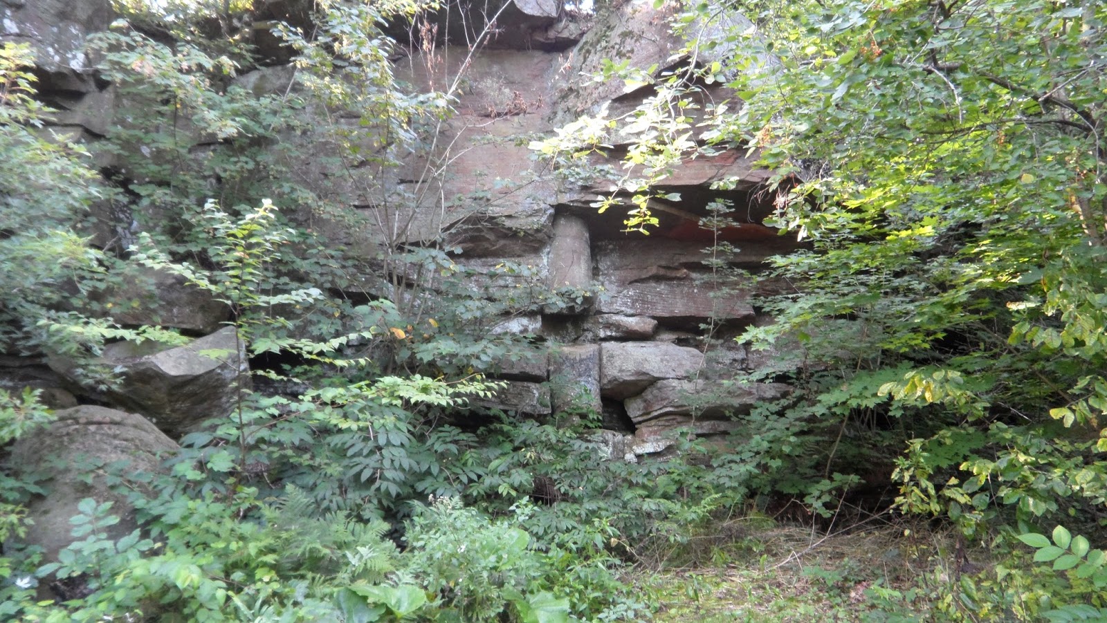
This curious structure is frequently observed in this section of the  country, and I do not recollect of having seen a satisfactory theory to account for its formation. These cylindrical masses are of all sizes, from three inches, to fifteen or twenty feet in diameter ; and their axes are always nearly, if not exactly vertical. At times, two or more encroach on each other.

The large circle represented in the following figure, is about twelve feet in diameter, at the locality in Somerville, and the whole is nearly of the same level. The concentric lines of stratification are sometimes obscure, but the cylindrical structure is always sufficiently apparent.
To no active agent can we attribute these interesting appearances with more plausibility, than that of water, revolving in the little vortices or eddies, and causing the sand, which is the principal constituent in the  rock, to be deposited in circular layers ; or entirely excavating a cylindrical cavity in the sand, before it had assumed the consistence of rock, and leaving it to be filled subsequently.

The following sketch is from the surface of the rock, in a field adjoining Somerville village.


The existence of smaller circular masses in the border of, or entirely within a larger one, without in the least interfering with the stratification of it, shows that the causes which produced them operated at distinct intervals of time, although their ages appear to be very nearly the same.

This must, upon the whole, be considered a very interesting problem
in Geology.  F. B. H.”    

The New York State Museum likely still has those specimens.  One of the museum’s web pages gives a partial summary of collections, contents and dates of acquisition, and mentions:  “In 1851 and 1852 minerals and geological specimens from Mr. Franklin B. Hough were added to the collections. These were mostly specimens from St. Lawrence County.”
http://www.nysm.nysed.gov/research_collections/collections/geology/mineralcollect.html

++++++++++++

In his later paper entitled  On the Cylindrical Structure Observed in Potsdam Sandstone, Franklin B. Hough reports on vertical cylinders in Potsdam sandstone in Jefferson and St. Lawrence Counties, New York, with diameters from two inches to twenty feet and upward, where the concentric lines are more conspicuous in those from one to two feet in thickness; that it is frequently observed that the larger masses contain within them those of a smaller size, sometimes partly within and partly without; that cylinders a foot in diameter, five feet in length, have been observed without change in size or structure; that a conical figure is occasionally observed with the cone directed downwards; that the strata often exhibit ripple marks; that a spheroidal structure, seldom larger than an orange, with perfect concentric stratification, is often met.  He proposed that “the cylindrical masses above described may have had their origin in small eddies, or whirlpools, produced by local causes acting upon the surface of the water, and transmitted to the sand at the bottom.  The conical figure occasionally observed, and more especially the uniform direction of the vertex fo the cone, confirm the idea, while all the attendant appearances unite to prove that they were produced in shallow water.   ... When two are found occupying the same area, it is evident that they were formed at distinct, although not probably at distant, intervals of time.”

[Hough, Franklin B., 1851, On the Cylindrical Structure Observed in Potsdam Sandstone,  Proceedings of the American Association for the Advancement of Science, Volume 4, pages 352-354]   

+++++++++++


Franklin B. Hough’s Additional References to Cylindrical Structures in the Potsdam Sandstone


Franklin B. Hough was a prolific writer.   He included geological notes in his general publications.  For example in 1853 he published his A History of St. Lawrence and Franklin Counties, from the earliest period to the present time (Albany, Little & Co., 708 pages).  This included Chapter XI on Geology, Mineralogy and Meteorology, which at pages  678 and 679 included a reference to the cylindrical structures when discussing the Potsdam sandstone:

“But perhaps there is no structure, either of this or of any other rock, more worthy of study then the remarkable cylindrical stratification frequently observed at Rossie, Antwerp, Theresa, &c.  These cylinders are vertical, and of all diameters, from two inches up to twenty feet or more, and their section where exposed to the surface, shows them to be made of concentric strata of sand of different colors and degrees of fineness, firmly consolidated and capable of being detached, when they present to the casual observer the appearance of huge logs of wood, and has led to them being called “petrified logs.”   As the kind of rock in which they occur does not possess cleavage, it is seldom quarried, and opportunities have not been found to learn the depth to which they descend.  From what the author has seen, he infers that they are sometimes conical, and probably run out at no great depth.... The cylinders at times encroach upon each other, the last formed being perfect, while the older has its stratification interrupted by the other.   No rational theory has occurred to us by which this wonderful structure could be explained , than that they were formed by vortices or whirlpool playing upon the surface of water, and imparting their gyrating motions to the mobile sands of the bottom, which gave the circular arrangement notice, and which has become consolidated and remains.”

In 1854 he published A history of Jefferson County in the state of New York, from the earliest period to the present time (Watertown, N.Y., Sterling & Riddell, 633 pages)  This included Chapter XV on Geology, Mineralogy, which at page 531 references the cylindrical structures in the Potsdam:

“In the vicinity of Theresa, Redwood, &c., there occurs in numerous places in this rock , the cylindrical structures, common at many localities in St. Lawrence county, and apparently produced by eddies acting upon the sands at the bottom of shallow water.”

In 1860 he published  A history of Lewis County, in the state of New York, from the beginning of its settlement to the present time  (Albany : Munsell & Rowland, 1860, 319 pages).  While he includes a section entitled Topography and Geology, and reports on outcrops of Potsdam Sandstone, he does not report any cylindrical structures.
   
++++++++++++


Franklin Hough’s Early Interest in Minerals


Franklin Hough’s interest in mineralogy and geology began when he was fifteen years old.  Here is an extract from his reminiscences:

“During the summer of 1837 ... Mr. Bannister... had visited a mineral locality, at or near the Natural Bridge, in Jefferson County, and gave me directions how to reach it.   I started out on foot, on a journey which must have been not less than twenty-five miles....  I found an abundance and variety of minerals which quite astonished me.  Augite, tabular spar, cocolite, sphene, tourmaline in large black crystals, scapolite, blue calcite, crystals of feldspar, quartz crystals lining cavities in chalcedony and other varieties ...  I found myself loaded with forty or fifty pound of treasures which I walked back over the twenty-five mile that I came.”

[As quoted in an article entitled Franklin B. Hough, M.D., Ph.D.,  by David Murray, 1886,
Annual Report of the Regents of the University of the State of New York,  Volume 99, pages 300-347 at pages 303-304 ]       

Murray also mentions that “During the summer of 1839 [Franklin Hough]  took a trip down the Mohawk valley to Saratoga and back, spending much of his time in collecting minerals, in which he had become greatly interested....”


Franklin B. Hough’s Additional Papers on Geology


In addition to the above two papers on cylindrical structures, and his three general interest publications on counties in New York which contained chapters on geology and minerals,  Franklin B. Hough authored or co-authored at least nine additional papers on geology.  Here are the papers  that I’ve found:

Hough, Franklin B., 1847, Observations on the Geology of Lewis County, New York, Volume 5, Am. Journal Sci. And Agric., pages 267-274, 314-327

Hough, Franklin B., 1850, New Mineral Localities in New York.  Silliman, Journal IX, [The American Journal of Science and Arts] pp 288-289

Hough, Franklin B., 1851, New American localities of  Minerals .  The American Journal of Science and Arts, Second Series, Volume XII,  pp 395-396

Hough, Franklin B., 1850, On the existing  Mineral Localities of Lewis, Jefferson and St. Lawrence counties,  New York.  Silliman, Journal IX, [The American Journal of Science and Arts] pp 424-429

Hough, Franklin B., 1851, On the association of certain minerals  in Northern New York.  Amer. Assoc. Proc. pp 205-206

Hough, Franklin B., 1851,  List of  Mineral and Geological Specimens Received From  Franklin B. Hough, A.M., M. D., of Somerville, St. Lawrence County, N. Y;  Fourth Annual Report of the Regents of the University on the Condition of the State Cabinet of Natural History and the Historical and Antiquarian Collection Annexed Thereto, State of New York, pages 82-90.

Hough, Franklin B., 1852, On the existence of diluvial agencies during the earlier geological periods.  Proceeding of the American Association for the Advancement of Science, [Held at Albany, New York, August, 1851] pp 262-264

Hough, Franklin B., 1852, A report on the mines and lands of the St. Lawrence Mining Company. New York, Arthur & Burnet, 9 pages

Hough, Franklin B. And S. W. Johnson, 1850, On the discovery of Sulphuret of Nickel in Northern New York.  Silliman, Journal IX, [The American Journal of Science and Arts] pp 287-288

Almost all of those papers are available from  https://archive.org/   or http://www.biodiversitylibrary.org


Donation of Minerals and Fossils  to the Smithsonian


In addition to donating specimens to the New York State museum, Dr. F. B. Hough donated a box of minerals and fossils from St. Lawrence County, New York to the Smithsonian
[See: Baird, Spencer F.  1851,  List of Principal Accessions to the Museum of the Smithsonian Institution Made Prior to January 1, 1851, in Annual Report of the Secretary of the Smithsonian Institution for the years 1850, 1851, pp 41-50, as quoted in George Brown Goode, 1883,    Bulletin No. 20 of the United States National Museum. ]

Unfortunately, while the Smithsonian has an online search engine that allows one to search the collections, I could not locate the specimens donated by Dr. Hough.

In 1873 Dr. Hough  donated a box of ethnological specimens to the Smithsonian.
   

Houghite -- A Mineral Named After Franklin B. Hough


Franklin B. Hough discovered a mineral that is named after him, Houghite, a variety of Hydrotalcite that is derived from the alteration of spinel. [C. U. Shepard, 1851, An Account of several new Mineral Species, American Association for the Advancement of Science, Volume 4, pages 311-319 at pages 314-315]    See also: www.mindat.org/min-27354.html 


Franklin B. Hough’s Original Notebooks, Maps and  Papers on Geology


The New York State Library keeps a collection of 117 boxes of Franklin B. Hough's papers that were donated to the New York State Library by the Hough Family in 1915.   Included in the collection is “a notebook with nine maps entitled “Mineral Localities of Northern New York,” and oversize manuscript copy maps of Lot 611 in the village of Philadelphia, Jefferson County, and a map showing townships in Jefferson, Lewis, and Herkimer counties in New York State.”
This would be worth looking by those with an interest in  historical mineral localities.

[See Franklin Benjamin Hough Papers - New York State Library
 http://www.nysl.nysed.gov/msscfa/sc7009.htm   ]


Other Aspects of Franklin Hough’s Life


Franklin B. Hough, M.D., had an interesting life.  I would recommend reading David Murray’s article from 1886 and the summary in the Franklin Benjamin Hough Papers - New York State Library at: http://www.nysl.nysed.gov/msscfa/sc7009.htm   The following is but a brief summary.

Franklin B. Hough, M.D., (1822-1885) was trained as a medical doctor, but practiced as a medical doctor only briefly from 1848 to 1852 and from 1862 to 1864 when he served as a surgeon during the American Civil War.   He is remembered today for his writings on botany, as a writer on historical topics, as the person responsible for overseeing the New York State census for 1855, 1865 and 1870, and as the father of American forestry.    His work on the census of New York revealed the declining availability of timber and caused him to devote the latter part of his life to the preservation of forests.   He should also be credited as the first to write on cylindrical structures in sedimentary rocks and for his early work in identifying mineral collecting localities in New York State.
       
Interestingly, Franklin B. Hough’s real name was Benjamin Franklin Hough.   In an account of himself, furnished in 1860 to the New England Historic Genealogical Society, he states that he was “originally named Benjamin Franklin Hough, but having a cousin of the same name, he assumed in childhood the name as now written [i.e., Franklin B. Hough], to distinguish him from his cousin.  The B.” he adds, “is retained without attaching to it any particular significance, and it is invariably written with the initials only.”

 [from a review of A Bibliography of the Writings of Franklin Benjamin Hough, Ph.D., M.D, by John H. Hickox., that appeared in Volume 40, New England Historical and Genealogy Register, 1886, page 423]

Christopher Brett
Perth, Ontario       


Thursday 27 August 2015

Cylindrical Structures in Potsdam Group Sandstone in Eastern Ontario - Part 2

My blog posting from January 29, 2014 provided an introduction to cylindrical structures found in Potsdam Group sandstone of Eastern Ontario, provided historical photographs of the Park of Pillars at the Hughes Quarry on the east bank of the Cataraqui River four miles above the locks at Kingston Mills, canvassed the theories on the origins of the cylindrical structures and listed a few of the locations in Eastern Ontario where the cylindrical structures can be found.


Cylindrical Structures at the Park of Pillars at the Hughes Quarry


This month provided an opportunity for me to visit the Park of Pillars at the Hughes Quarry.   When I learned that the Niagara Peninsula Geological Society had organized a two day field trip to Eastern Ontario, with a stop on Sunday, August 16 scheduled for the Park of Pillars, I had to go.  I joined the Niagara Peninsula Geological Society and signed up for the field trip.  I was glad that I did as it was a very enjoyable field trip.   I don’t know if I’ve ever been on field trip with people so enthusiastic about rocks.

Below are three photos taken at the Park of Pillars.  The gentleman that is the scale in the first photo is a little over six feet tall and is holding a meter stick.   The second photo shows the concentric rings visible on the underside of the cylindrical structure shown in the first photo.   The third photo shows a much larger cylindrical structure about ten feet to the left of the first structure.   My photos show the same cylindrical structures figured in the historical references mentioned  and reproduced in my earlier blog posting.


Dave Forsyth of Arnprior was our guide.  Dave pointed out that the alteration extends beyond the cylinders into the surrounding rock and does not end at the fractures that define the cylinders.

An Occurrence 4.5 kilometers South of Elgin


My earlier blog posting  mentioned a few of the locations in Eastern Ontario where the cylindrical structures can be found.    One additional location that is worth mentioning is referenced by Sanford and Arnott (2010):

“A similar but much smaller columnar structure was found in the Chippewa Bay Member of the Covey Hill Formation [of the Potsdam Group Sandstone] at station O-30 approximately 4.5 km southeast of Elgin, Ontario (Fig. 42.a, b).”

[B.V.  Sanford and R.W.C. Arnott (2010), Stratigraphic and structural framework of the Potsdam Group in eastern Ontario, western Quebec and northern New York State, GSC Bulletin 597, at page 43] 

Sanford and Arnott’s description of the two photos that are Figure 42 is as follows:  

“Figure 42.  Miniature cylindrical column in the Covey Hill Formation (Chippewa Bay Member), 45. Km southeast of Elgin, Ontario at station O-30.  a) Plan view of the small columnar structure...b) Partially exposed cross-sectional view of the column.”

This past weekend while returning from an auction I decided to look south of Elgin for cylindrical structures.   While I didn’t find the outcrop that appears in Sanford and Arnott’s publication  (I  must have been very close to their outcrop as I would plot my outcrop on the map that accompanies their report in the identical location as their station O-30), I  found an outcrop which shows numerous circular and concentric structures weathering out of sandstone.    Below are four of the photographs that I took.


The circular and concentric structures that I found are generally in the range of 5 to 18 cm (2 to 7 inches) in diameter.  I believe these circular and concentric structures to be cross-sections of numerous small, cylindrical structures.

The outcrop is a horizontal, glacially polished, surface of off-white sandstone.  It is  about the size of half a soccer pitch, a third of which exhibits circular and concentric structures.  I didn’t count the circular and concentric structures but there had to have been  over two hundred of them.

While I believe these circular and  concentric structures to be  cross-sections of cylinders, they could represent cross-sections through spherical concretions or cones.   Both rounded concretions and conical (funnel shaped) structures  have been reported in the Potsdam sandstones.

Dr. R. W. Ells of the Geological Survey of Canada was probably the first to report on rounded concretions in the Potsdam sandstone in Canada  when discussing the cylindrical structures at Gildersleeve’s Quarry,  now referred to as Hughes Quarry:

“In the quarry several curious cylindrical concretions occur which resemble the trunks of fossil trees, and at one time they were regarded as such.  They stand upright in the face of the quarry, the two principal ones having diameters of three and four feet, with an outer zone of three inches or more in concentric layers, corresponding to what would have been the bark if the structures had been organic....Numerous rounded concretions, from half an inch to two inches in diameter are found in the vicinity of the supposed trees, which by some persons have been regarded as the fruit.  Rounded concretions of this kind are found in similar sandstones at the southern end of Knowlton lake.”

[Ells, R.W., 1905, The District Around Kingston, Ontario, Annual Report (New Series) for 1901, Volume XIV, Geological Survey of Canada, Report A, at page 176A]
   
A recent reference to a conical structure in Potsdam sandstone is that “an example of an upward expanding (funnel shaped) cone is observed on Jones Falls Road, Ontario, 2.5 km west of Highway 15, at station O-29" (B.V.  Sanford and R.W.C. Arnott (2010), at page 41).

Round concretions and conical structures have also been reported with the vertical cylinders in the Potsdam sandstone in Jefferson and St. Lawrence counties, New York (Hough, 1850; Dietrich, 1953).   Hough reported on vertical cylinders, associated conical structures, and associated spheroidal structures that were “seldom larger than an orange, usually occurring together in great numbers.  When broken they present a perfect concentric stratification....” [Hough, Franklin B., 1851, On the Cylindrical Structure Observed in Potsdam Sandstone,  Proceedings of the American Association for the Advancement of Science, Volume 4, pages 352-354]

Dietrich  reported that  “Two cylindrical structures, one inverted conical structure and seven structures having circular horizontal sections and vertical sections of unknown shapes occur in the Upper Cambrian Potsdam sandstone two miles north of Redwood, New York.” [[Dietrich, R.V. (1953), Conical and Cylindrical structures in the Potsdam Sandstone, Redwood, New York, New York State Museum Circular 34, at page 1]  He found a cylinder 15 feet in diameter and more than 9 feet in length, a cylinder 15 inches in diameter and more than four feet in length, and seven circular horizontal sections with diameters ranging from 2 inches to three and a half feet.

References to Cylindrical Structures found in Lanark County


I have not yet found an outcrop in Lanark County showing cylindrical structures in sandstone, but have noted that part of a sandstone cylinder is on display at the Perth museum and have found additional references to them as having been found in Lanark.   (I say “additional” because my earlier posting mentioned  specimens from Almonte in McGill’s collection  that were referred to by Dawson (1890).)

Not surprisingly, the first reference refers to Doctor James Wilson of Perth:

“In the sandstones near Perth the late Dr. Wilson, nearly thirty years ago, found a number of long cylindrical casts like tree trunks from six inches to one foot in diameter.   Last year attention was called to certain cylindrical bodies of larger size than the above which pass almost at right angles through the sandstone beds of this formation near the Rideau canal about eight miles from Kingston.”

[Report of the Royal Commission Upon the Mineral Resources of Ontario and Measures for their Development, 1890, Toronto, Warwick & Sons, at page 40]

I’ve also noted that  Jean Dugas, who provided the marginal notes to geological  Map 1089A, mentions that cylindrical or conical structures can be found in North Elmsley Township,  Lanark County.   She commented:

“Peculiar bands showing cylindrical or conical structures noted in the Nepean formation, and best observed on lot 24, Con. VI, North Elmsley tp., are the same composition as the surrounding sandstone , but cut sharply across the beds and are themselves bedded parallel with the walls of the structures.  They are probably formed by slumping of the sand due to water structures.”

[M.E. Wilson and Jean Dugas, 1961, Map 1089A, Geology, Perth, Lanark and Leeds Counties, Ontario, Geological Survey of Canada, Geology by M. E. Wilson, 1930 and Jean Dugas, 1949, Descriptive notes by Jean Dugas.]
                   
Lot 24 of Concession VI in North Elmsley Township is 2 km west of Rideau Ferry and lies south of County Road 1.  

I have not been able to find Wilson and Dugas’ occurrence in Lot 24 of Concession VI in North Elmsley Township.  Wilson and Dugas’ map shows only two outcrops on that lot.  I found one of their outcrops.   It is about 4 feet high and over 30 yards long and is now part of the front lawns of three houses on West Point Drive that back onto Big Rideau Lake.   Crossbedding is visible, but no cylindrical structures could be found on the vertical face of the outcrop. Unfortunately, landscaping (topsoil and grass) has obliterated the top of the outcrop.

In an earlier blog posting discussing Perthite I mentioned that  Jean Dugas had presented her doctorate thesis on the rocks of this area  (Dugas, Jean, 1952, Geology of the Perth map area, Lanark and Leeds Counties, Ontario; Ph. D., McGill).   Unfortunately it is not possible for me to check her thesis to confirm the lot and concession number as her thesis has not been digitized and made available online.

In the early 1980's the Ontario Geological Survey re-mapped the Paleozoic rocks in Eastern Ontario.   Williams and Wolf, who mapped the Perth area,  reported that  “cylindrical structures have been reported by Wilson and Dugas (1961)” [Williams, D.A. and Wolf, R.R., 1984, Paleozoic Geology of the Perth Area, Southern Ontario; Ontario Geological Survey, Map P.2724, Geological Series -Preliminary Map. Scale 1:50,000. Geology, 1982].  However, they did not report finding cylindrical structures.   Further, Williams and Wolf ‘s  Map P.2724 shows no outcrop in Lot 24 of Concession VI in North Elmsley Township.

Additional References to Cylindrical and Conical Structures in Sandstone in Eastern Ontario


My blog posting from January 29, 2014 listed a few of the locations in Eastern Ontario where cylindrical structures can be found in Potsdam sandstone.   Here are additional locations:

1)  2 km north of Morton, roadcut off Highway 15


“Crossbedding is common, and unique cylindrical structures or “pillars” (Dietrich 1953) were observed in a roadcut along Highway 15, 2 km north of Morton.”
[Williams, D.A. and Wolf, R.R. 1984, Paleozoic Geology of the Westport Area, Southern Ontario; Ontario Geological Survey, Map P.2723, Geological Series -Preliminary Map. Scale 1:50,000. Geology, 1982, in marginal notes]
“Sandstone pillars have been reported in the Perth area by Wilson and Dugas (1961), and were observed at several localities in the Westport map area (31C/0).  Excellent examples are present in the Highway 15 roadcut 2 km north of Morton (UTM 404120E, 4934250N) (Plate 4).”
Plate 4 is a photograph of the “Cylindrical structure in quartz sandstone of the Nepean Formation, Highway 15 roadcut 2 km north of Morton”.
[Williams, D.A., 1991, Paleozoic Geology of the Ottawa-St. Lawrence Lowland, Southern Ontario; Ontario Geological Survey, Open File Report 5770, 292 pages, at pages 44 and 41.]


2)  Washburn Road, west of Highway 15 and close to Rideau Canal


Source: personal communication, Dave Forsyth, 2015.
   

3)  Along southern Melville Island in St. Lawrence River


“A thicker section of sandstone beds is found in a block along southern Melville Island (Fig. 16),  The exposed face displays crossbedding at several levels within the concave-up beds that may be the foreset beds within a large subaqueous dune.  The lower image details conglomerate beds, crossbedding and an eroded section of a dewatering structure.”   “Fig. 16. Sandstone block with conglomerate and cross-beds; dewatering cylinder at right edge of block.”
[Al Donaldson, Dave Forsyth, Chris Findlay and Bud Andress, 2010,
Fall Geology/Ecology Boat Tour - St. Lawrence River  1000  Islands, at page 20
http://www.frontenacarchbiosphere.ca/explore/fab-education/geology/st-lawrence-river-thousand-islands-geology-boat-tour ]

4) South March Highlands, Kanata


The South March Highlands border Kanata and are south of March Road, east of Huntmar, west of March Road and north of Terry Fox Drive.  A Photo with the legend “unequivocal dewatering cylinders preserved in Paleozoic sandstone - An Ancient Spring.” appears at page 14 in a 49 page presentation (in pdf format) entitled “Ottawa’s Great Forest: The South March Highlands” prepared by Carp River Conservation Inc. that can be downloaded from 
http://www.renaud.ca/public/Presentations/2011-05-17%20SMH%20Overview%20v17.pdf   


5) On Huckleberry Island in the St. Lawrence River near Gananoque, Ontario

   
A photo of this cylindrical structure is Plate 124, which appears between  pages 1030 and 1031,  in

J. E. Hawley and R. C. Hart, 1933
Cylindrical Structures in Sandstone, Bulletin of the Geological Society of America, Volume 44, pages 1017-1034
    

6) Near Westport, Ontario


Source:  J. E. Hawley and R. C. Hart , 1933, at page 1020.       

7) Jones Falls


Sanford and Arnott report that “an example of an upward expanding (funnel-shaped) cone is observed at Jones Falls  Road, 2.5 km west of Highway 15, at Station O-29 .”

B.V. Sanford and R.W.C. Arnott, 2010,
Stratigraphic and structural framework of the Potsdam Group in eastern Ontario, western Quebec, and northern New York State; Geological Survey of Canada, Bulletin 597


Christopher Brett
Perth, Ontario


Tuesday 18 August 2015

If there's something strange in your neighborhood, who you gonna call?

 
Those that watched movies in the mid-1980's or had kids who watched television in the late 1980's will instantly recognize the title of this posting as the first line of the theme song for the movie Ghostbusters,  a 1984 comedy film starring Bill Murray,  Dan Aykroyd and Harold Ramis as three parapsychologists who start a ghost-catching business in New York City, with Sigourney Weaver as their most important client and Rick Moranis as her neighbor.   It was also the theme song for The Real Ghostbusters, an animated television series, a spinoff of the 1984 movie, that ran from 1986 to 1991. 

The question posed by the song title “If there's something strange in your neighborhood, who you gonna call?” seems to apply to the following three specimens that were recently quarried from Potsdam sandstone north of Kingston.   These strange specimens  were shown to me on Sunday by Jimmy Jackson, the owner of Rideauview Contracts, which operates a number of quarries in Eastern Ontario, including the sandstone quarry at Ellisville, Ontario

Jimmy Jackson had a lot of fun with the specimens.   The first he called “the Wolf” and the second, “an insole, size 11.”    I have to admit that I’ve never  seen anything like these specimens.

Specimen 1 - The Wolf


The first specimen has white sandstone arguably taking the shape of a wolf on the vertical surface of a block of  red sandstone,  and was collected because of that image.


When split horizontally it shows white sandstone taking various rounded, globular shapes in the red sandstone.


Specimen 2


A second similar specimen, also split horizontally (and partially wetted by Jimmy to enhance the contrast in colours), shows  similar rounded, globular shapes.


The next photo is a side view of part of the second specimen.


The first two specimens, each of which is in two parts,  were quarried from the same beds that produced  specimen 7 on my July 16, 2015 posting and specimens 1 and 2  on my June 30, 2015 posting.  I believe the beds to be the Hannawa Falls Member of the Covey Hill Formation of the Potsdam Group. 

When asked by Jimmy to provide an explanation for the shape I had to admit that I couldn’t answer his question.   On further reflection I suspect that it could be an example of chemical precipitation (leisegang banding  is present at other spots in the quarry, and a number of cylindrical dewatering structures have been found within 30 meters of these beds).   However, as the white sandstone is the colour of the overlying sandstone I suspect that it is more likely that cavities developed in the red sandstone beds that were filled in with the white sandstone.  This of course raises the question “What caused the cavities?”   Was it water percolating through the ground or burrowing?


Specimen 3 - Insole, Size 11


I suspect that there is a more scientific way to describe this shape, but Jimmy’s description of a size 11 insole is probably the most apt.  

This specimen I believe to be an example of chemical precipitation ( and it looks like banding   present at other spots in the quarry). 

I had thought about contacting another geologist for a second opinion, and adding his name in the title of the blog after the question “If there's something strange, in your neighbourhood,
Who you gonna call?”    On further reflection I realized this would be a mistake.  First, you wouldn’t believe how hard it is to find a paleontologist or geologist with a name that has the same number of syllables as the word “Ghostbusters” with a strong first syllable.   Second, I realized that this person would have to have a sense of humour, and wouldn’t mind being tagged with the Ghostbusters theme song.

Christopher Brett
Perth, Ontario

I ain't afraid of no ghost.   I ain't afraid of no ghost.

++++++++++++++++++++++++++++++++++

Added August 20th:
I received the following helpful comment:
“Hi, Christopher--I've been enjoying your blog posts!
I suspect the first two specimens are reduction halos, similar to those seen here: http://www.southampton.ac.uk/~imw/Budleigh-Salterton.htm (scroll down to about halfway down the long page). I've seen examples in many red iron-stained rocks. I'd concur with your interpretation of "specimen 3", mineral banding ("liesegang").
--Howard Allen”

I’ve had a look at the photos on the web page that Howard Allen referenced and agree with him that the photos on my blog could show a similar feature.   The web site at the link he provides mentions that  the “the reduction features are locally associated with dark grey radioactive nodules that contain high proportions of metallic elements including vanadium, uranium, copper and nickel”.   There are concentrations of  minerals at the centers of the globular features in my photos, which could we worth investigating.  

That web site also references the paper: Bateson, J.H. and Johnson, C.C. 1992. Reduction and related phenomena in the New Red Sandstone of south-west England. British Geological Survey Technical Report, WP/92/1 , which can be downloaded from http://nora.nerc.ac.uk/509450/

Bateson and Johnson mention:
“Hofmann (1991) in his study concludes that the weight of evidence from a wide variety of locations, geological environments and ages, points towards a genesis for the reduction phenomena and accumulation of exotic elements that assumes a supply of porewater containing both the reductants and exotica (p 121). The localisation of the reduction spots, according to Hofmann's hypothesis, would seem to be related to the presence of bacteria.”

HOFMANN, Beda A. 1991. Mineralogy and geochemistry of reduction spheroids in Red Beds.
Mineralogy and Petrology, Vol 44, 107-124.
http://link.springer.com/article/10.1007%2FBF01167103

++++++++++++++++++++++++++++++++++