In various blog postings dated from 2014 to 2016 I included photographs of cylindrical dewatering structures in the Cambrian Potsdam sandstone of Eastern Ontario.
For my October 22, 2019 blog posting I provided photographs of a concentric, circular structure observed in slabs of rock at a quarry mapped as the Ordovician Gull River Formation by the Ontario Geological Survey.
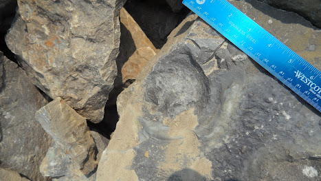
Below are three photographs of circular structures in two slabs of dolostone in Lanark County, just west of Carleton Place, where the rock has been mapped as the March (Theresa) formation by Williams and Wolf (1984) of the Ontario Geological Survey. The second photo is a close up of the first slab. The third photo is of a separate slab.
The blue ruler records inches and centimeters.
The concentric structures are about four inches (14 cm) in diameter. The structures appear to be stromatolites or oncolites, both microbial structures. In their marginal notes to Map P. 2725, Williams and Wolf (1984) mention that “algal mats and stromatolites are common” in the March Formation. An alternate interpretation is that these structures represent concentric microbial discoid structures similar to microbial-related biogenic structures from the Middle Ordovician slates of northern Portugal reported by Neto de Carvalho et al. (2016).
[added November 23, 2021:] Giles (1976; pages 53-59) reported both oncolites and stromatolites in Beekmantown dolostones in Eastern Ontario for his Prescott formation, which would be roughly equivalent to Alice E. Wilson’s March Formation. The oncolites were “spheroidal, commonly oblong or elongate in shape, and are visibly banded around intraclasts of dolostone, gastropod fragments or other fossil fragments.” The maximum diameter he recorded at two localities was 2.6 inches (6.8 cm) and 4 inches (10 cm).
Ovoid Burrow
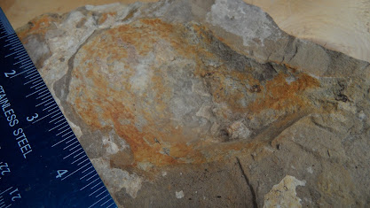
Below is a photograph of an ovoid, scooped out, structure in a loose slab of sandy dolomite from the same locality. The ovoid structure is about 10 centimeters long by 7 centimeters wide by 3 centimeters deep. It appears to be trace fossil – possibly a dwelling or feeding burrow with a narrow , 1 cm wide, entrance at the upper right.
Below is an enlarged view of this structure.
Christopher Brett
Ottawa
References and Suggested Reading
Brett, Christopher, 2014-2016
January 29, 2014 - Cylindrical Structures in Potsdam Group Sandstone in Eastern Ontario
August 27, 2015 - Cylindrical Structures in Potsdam Group Sandstone in Eastern Ontario - Part 2
September 28, 2015 - A Map Showing the Location of Cylindrical and Conical Structures in Potsdam (Group) Sandstone of Ontario and New York
October 22, 2015 - Cylindrical structures in Sandstone: A Type of Soft-Sediment Deformation Sometimes Linked to Seismic Activity
December 23, 2015 - Dewatering Structures, Biofilm Structures, Glacial Striae and Chatter Marks in Potsdam Sandstone near Newboro, Eastern Ontario
September 22, 2016 - Frothed Sandstone and Cylindrical Structures Found in Potsdam Sandstone
Fossilslanark.blogspot.ca
Brett, Christopher, 2019
A Concentric Circular Structure in Rocks of the Ottawa Embayment that are Mapped as the Ordovician Gull River Formation. Blog posting dated Tuesday, 22 October 2019
http://fossilslanark.blogspot.com/2019/10/a-concentric-circular-structure-in.html
Giles, P. S. 1976.
Stratigraphy, petrology, and diagenesis of Beekmantown carbonate rocks. Ph.D. thesis, University of Western Ontario, London, Ontario
https://ir.lib.uwo.ca/digitizedtheses/904/
Neto de Carvalho, C. , Couto, H., Figueiredo, M. V., and A. Baucon, 2016
Microbial-related biogenic structures from the Middle Ordovician slates of Canelas (northern Portugal). Comunicações Geológicas (2016) 103, Especial I, 23-38
https://www.researchgate.net/journal/Comunicacoes-Geologicas-0873-948X
Williams, D.A., and Wolf, R.R., 1984
Paleozoic Geology of the Carleton Place Area, Southern Ontario; Ontario Geological Survey, Map P. 2725, Geological Series-Preliminary Map, scale 1:50 000. Geology 1982.


