Sunday 27 February 2022

Ediacaran Fossils in Blocks at the Base of the Big Ben Statue in Perth, Ontario

The bronze statue of Big Ben and Ian Millar in Stewart Park in Perth, Ontario will be familiar to all who live in Lanark County.   Located opposite Code’s Mill on Wilson Street in Perth it is a tourist draw for all those who are fans of equestrian events.   What is not so well known is that the thick slabs of rock at the base of the statue were quarried from Tackaberry’s quarry on Highway 7 north of Perth and, more importantly, are Ediacaran rocks from the quarry and contain examples of the concentric, circular Ediacaran fossil Aspidella.

Below are photographs of a few of the concentric circular structures in the rock slabs at the base of the statue.


The circular structures are the Ediacaran fossil Aspidella.  The first photo shows two circular structures. The second and third  photos show closeups of single circular structures. The fourth photo shows at least ten circular structures.  The circular structures are about two centimeters in diameter.  (They are easier to spot on the slabs than in the photos.)

The tops of at least five of the large slabs that function as retaining walls bear the circular structures.  

Other blocks and slabs of Ediacaran rock can be found at various places in Perth.  Some are used as steps for buildings, benches in parks and patio stones.  Some exhibit microbially induced sedimentary structures. 

I have included photographs of Aspidella specimens in rock at two of Tackaberry's quarries in Lanark County in previous blog postings.

Christopher Brett
Ottawa, Ontario

References and Suggested Reading

Anonymous
Big Ben & Ian Millar.   https://www.beautifulperth.com/bigben.html
Brett, C. P., 2019a
Concentric Structures in the Sedimentary Rocks of Lanark County, Ontario that are identical to the Ediacaran Holdfast Aspidella.  Blog posting dated   March 8, 2019  
http://fossilslanark.blogspot.com/2019/03/holdfasts-in-lower-ordovician-march.html

Brett, C. P., 2019b
Possible Fossil Microbial Mat Structures in Rocks Near Perth, Ontario.  Blog posting dated   March 28, 2019.  http://fossilslanark.blogspot.com/2019/03/possible-fossil-microbial-mat.html

Brett, C. P., 2019c
A Selection of Fossils from the ‘March Formation’ in Lanark County, Ontario - A Correction.  Blog posting dated  March 24, 2019
http://fossilslanark.blogspot.com/2019/03/a-selection-of-fossils-from-march.html

Brett, C. P., 2019d
If the Ediacaran discoid holdfast Aspidella, why not Ediacaran Stalks, Spindles and Fronds in Lanark County?   Blog posting dated   March 29, 2019
http://fossilslanark.blogspot.com/2019/03/if-ediacaran-discoid-holdfast-aspidella.html

Brett, C. P., 2019e
Photographs of GSC 221, one of Alexander Murray’s specimens of Aspidella terranovica, Billings 1872. Blog posting dated Wednesday, May 1,  2019

 Brett, C. P., 2019f
A Chronology of References to Aspidella terranovica from its Discovery by Murray, Naming in 1872 by Billings, Through the Initial Period when it was Recognized as a Fossil, Through the Decades when it was Dismissed as an Inorganic Concretion or Gas Escape Structure, to its Resurrection in the late 20th Century, and Crowning in 2000 as the First Named Ediacaran Body Fossil.  Blog posting dated Sunday, June 30, 2019 

Brett, C. P., 2020
Dave Forsyth’s Photographs of Aspidella from the Richmond Quarry, Lanark County
Blog posting dated Thursday, August 27, 2020
http://fossilslanark.blogspot.com/2020/08/dave-forsyths-photographs-of-aspidella.html
  
Burzynski,  Greg,  T. Alexander Dececchi, Guy M. Narbonne & Robert W. Dalrymple, 2020
Cryogenian Aspidella from northwestern Canada.  Precambrian Research.  Volume 336, January 2020, 105507  https://doi.org/10.1016/j.precamres.2019.105507
Liu, A.G., Tindal, B.H., 2021
Ediacaran macrofossils prior to the ~580 Ma Gaskiers glaciation in Newfoundland, Canada 
 Lethaia, Volume54, Issue2 April 2021 Pages 260-270
https://doi.org/10.1111/let.12401

Schwid, M.F., Xiao, S., Nolan, M.R., An, Z., 2021
Differential Weathering of Diagenetic Concretions and the Formation of Neoproterozoic Annulated Discoidal Structures PALAIOS (2021) 36 (1): 15–27.
https://doi.org/10.2110/palo.2020.018
 
Segessenman, Daniel C.  And Shanan E. Peters, 2022
Macrostratigraphy of the Ediacaran System in North America.  In  Geological Society of America special publication entitled Laurentia: An Evolving Continent GSA Memoir.
https://eartharxiv.org/repository/list/?page=2

Tarhan, Lidya G.,  Mary L.Droser, James G.Gehling & Matthew P.Dzaugis, 2015
Taphonomy and morphology of the Ediacara form genus Aspidella
Precambrian Research. Volume 257, February 2015, Pages 124-136
https://doi.org/10.1016/j.precamres.2014.11.026


Tuesday 25 January 2022

An Iron Ore Deposit in the Potsdam Sandstone of Eastern Ontario: The Hematite Deposit Between Delta and Furnace Falls - Part 2

 Part 1 is my November 18, 2012 blog posting.  In that posting I relied on Murray (1852) who identified the hematite occurrences on Lots 23, 24 and 25 in the tenth concession of Bastard Township, just south of Delta, and east of Lower Beverley Lake, as the likely source for the iron ore smelted at Furnace Falls (now, Lyndhurst).   It appears the Murray (1852) was wrong and that I was wrong, as that deposit was discovered after the smelter at Furnace Falls ceased operations.

In 2018 I was contacted by email by Ken Watson, who for over twenty years has done volunteer work for the Old Stone Mill at Delta, Ontario and has written extensively on the Rideau Canal.  Ken told me that he had noticed my November 18th, 2012 blog posting on the hematite deposit between Delta and Furnace Falls (now Lyndhurst) and wanted to let me know that he was investigating the source for the iron smelted at Furnace Falls and that Art Shaw was having archaeological work done on the Lansdowne Ironworks at Lyndhurst.  At that time we exchanged a few emails.  On January 6, 2022  Ken Watson sent me an email telling me that he and Art Shaw have published three articles on the Lansdowne Iron Works at Furnace Falls and the source for the iron used at the iron works.   The three articles are:  

    Art Shaw, 2018 - The Lansdowne Iron Works NHS Lyndhurst, Ontario

    Art Shaw & Ken Watson, 2018 - Delta and Lyndhurst – Forged Together

    Ken W. Watson, 2021 - The Source of the Iron Ore for the Lansdowne Iron Works

The three articles can be downloaded from the web site for the Old Stone Mill at Delta, Ontario:

 http://www.deltamill.org/history.html    All are worth reading.

Ken’s research strongly suggests that the hematite deposits adjoining Lower Beverley Lake that were identified by Murray (1852)  were likely not the source for the iron smelted at Furnace Falls.  While Murray (1852) identified the occurrences in the tenth concession of Bastard Township as the source for the ore smelted at Furnace Falls, Ken’s research shows that they had not been discovered when Sunderlin’s smelter at Furnace Falls was in operation.   Ken’s research suggests that the likely sources close to Lyndhurst include the following:

a) hematite in outcrops of sandstone near Furnace Falls, that were quickly exhausted [see Shaw, 2018, quoting Sunderlin 1807 that “ the ore adjoining the works did not turn out as expected”] ;

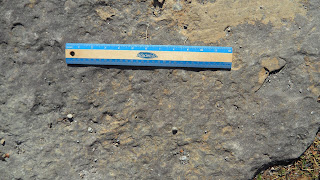
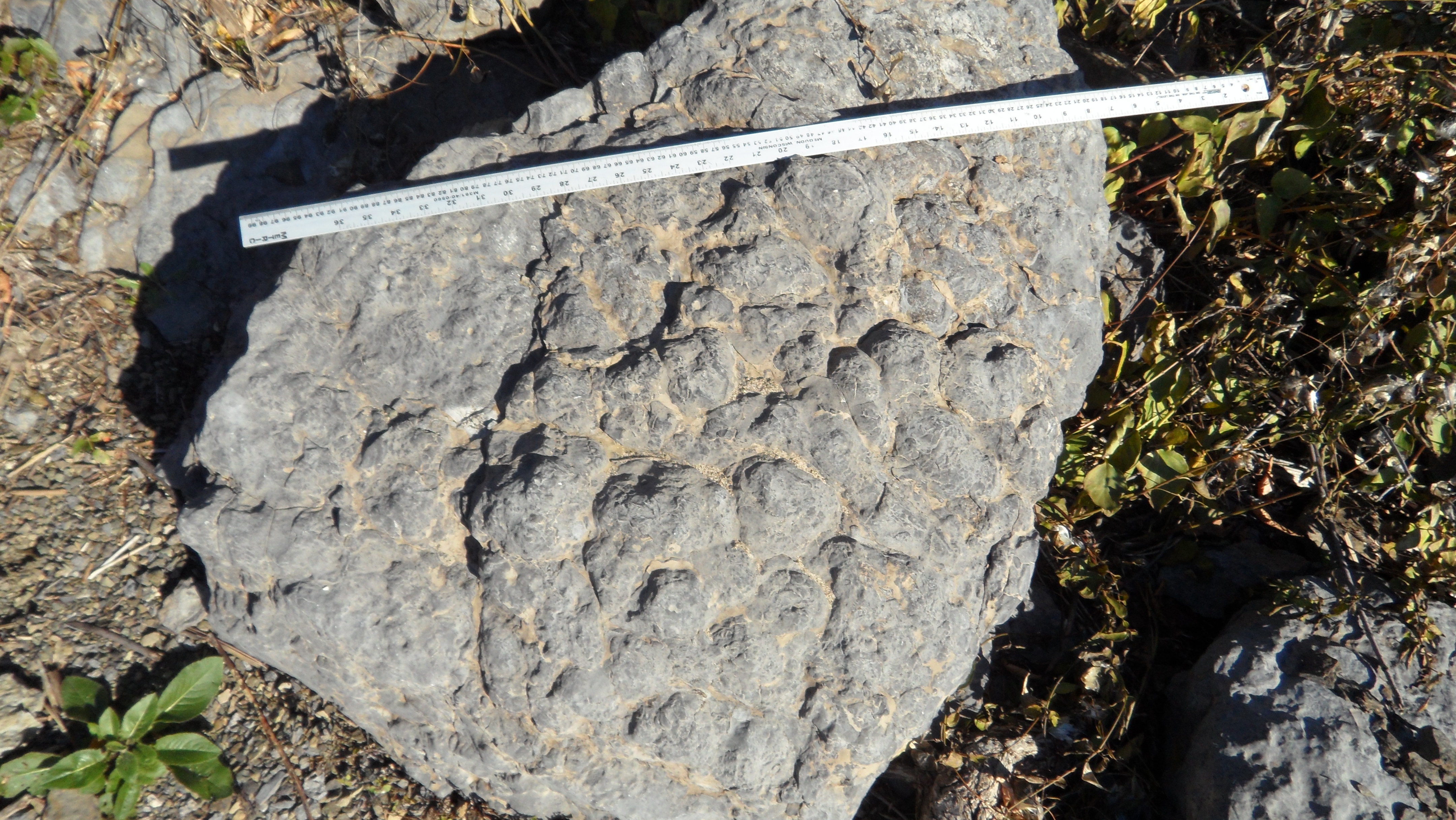
b) hematite in outcrops of sandstone on Sunderlin’s property on lots 11, 12 and 13 of Concession XIII of Lansdowne Township, about two kilometers to the east of the occurrences identified by Murray, and only 100 meters to a kilometer east of the outcrop of hematite in sandstone on County Road 42  mentioned in my blog posting, and six kilometers northeast of Lyndhurst;

c) hematite in outcrops on lot 10 of Concession XI of Lansdowne Township (see Wing,1800), about two kilometers southeast of the occurrences identified by Murray, and three to four kilometers northeast of Lyndhurst. 

Ken Watson’s (2021)  Map 3 clearly shows the location of those deposits in relation to Lyndhurst and to the hematite deposits east of Lower Beverley Lake.   For those that don’t bother looking at the map, it is worth noting that Concession X of Bastard Township borders the township line with Lansdowne township, and that Sunderlin’s lots on  Concession XIII of Lansdowne Township border the township line with Bastard township.

Ken concludes “What we are left with today is the knowledge of several potential sources of iron in the vicinity of Lyndhurst with a likelihood that the Lower Beverley Lake iron deposit[s] were not known and were not used to supply the furnaces at Lyndhurst.”    

What is known for certain is that eight sleigh loads of iron ore were taken from the 2nd Concession of Montague Township (between Smith Falls and Merrickville) and smelted at Furnace Falls.   I have deliberately used the word ‘taken’ as Art Shaw (2018) mentions that “In February 1803, Justice of the Peace Thomas Smith, for whom Smiths Falls was later named, took a deposition by John Covell, accusing Wallis Sunderlin, Peleg Sunderlin, Steven Washburn, William Stevens, William Patterson, Abel Stevens Jr and Adam Shook of stealing 8 sleigh loads of iron ore from his property in the 2nd Concession of Montague Township, between Merrickville and Smiths Falls. The circumstances suggest that the ore was probably mined by prearrangement for that purpose, but Sunderlin’s need for the immediate delivery of the ore, at some point overcame all other considerations, including his ability to pay. The extreme of taking eight teams of horses or oxen with drivers, 40 miles north through the wilderness in winter, and returning across frozen rivers and lakes with eight sleighs loaded with ore, is a testament to his desperation.”

Lieutenant  Baddeley’s (1831) Report on the Lower Beverley Lake Deposit

Ken’s email reminded me that since I published my original blog posting on the subject I had come across an article by  Lieutenant  Baddeley of the Royal Engineers published in 1831 discussing the occurrence at Lower Beverley Lake.    Lieutenant  Baddeley  (1831) agrees with Ken’s analysis that the deposit adjacent Lower Beverley Lake (then known as Henderson's Lake or Beverley Lake) was discovered “long after” the smelter at Furnace Falls was abandoned.   Here is part of Lieutenant  Baddeley’s (1831) report: 

“Red Oxide of Iron [hematite]  has been noticed in two or three places in Canada, but most abundantly in the neighbourhood of Henderson's Lake, on the Gannanoqui, where it forms apparently an extensive bed in a ferruginous sandstone (old red sandstone).   

At the Furnace Falls about three miles below this deposit there was formerly a smelting establishment, where some few articles were manufactured, not however from the ore above alluded to, as that was discovered long after these works were deserted, and none of it appears to have been smelted for any other purpose than experiment, which is said to have been favorable.    ...   

The deposit here alluded to is situated on the eastern shore of Beverley or Henderson's lake, an enlargement of the Gannanoqui, in the upper portion of its navigable waters. It is about one quarter of a mile from the lake, on the opposite side of a cedar swamp, and on the summit of a small hill. An inhabitant of Beverley [now called  Delta] desirous of ascertaining whether it was in abundance or not, opened a portion of the ground about ten feet every way, and found a considerable quantity. He seems to have struck a vein of it at the depth of about eight feet, which dips towards the north-east. But it also appears in the section he has made in large heavy blocks on and near the surface. I examined the ground in several places to the northward and eastward of this excavation, and always found it near the surface, it was also met with to the westward. As I remained on the spot only twenty minutes or half an hour, it is not possible to pronounce as to the quantity in which it occurs, it however, appears to be considerable. To obtain positive information on this point, it would be necessary to cut a few sections or sink a few holes on the hill, which might be done at a trifling expense— an expense amply repaid by even the chance of finding an extensive bed of ore in so desirable a locality.”

Lieutenant  Baddeley also provided an extensive report on the iron minerals present.

Pilon (2003), who prepared a short biographical note on Baddeley (Lieutenant, then Captain, Major and Major General),  mentions that Lieutenant  Baddeley was posted to Quebec in Lower Canada in 1821, and comments that “Baddeley was one of the original members of the Literary and Historical Society of Quebec in 1824 and served as its president in 1829. He read numerous papers before the society describing exploring expeditions he undertook in Canada and giving his observations on the geology of the country.”  I have not been able to determine when between 1821 and 1830 Lieutenant  Baddeley visited the occurrence  at Lower Beverley Lake.

Iron Ore Taken by Sunderlin from Montague Township, Lanark County

In a separate email Ken mentioned that he had not followed up on the iron ore occurrence in Montague Township, other than to note the it is mentioned in Glenn Lockwood ‘s history of  Montague township.   This was a reference to:

Lockwood, Glenn J.   1980  -  Montague: A Social History Of An Irish Ontario Town Ship 1783-1980; Publisher: Township of Montague, 639pp

Lockwood (1980, page 242) quotes from an article from the July 20, 1865 edition of the Smith’s Falls Review discussing the proposed iron mine stating “That ore exists there in inexhaustible quantities cannot be questioned. In various parts before coming to Roseville "surface indications," ...  are plainly observable, and the beds of it can generally be traced as far as the elevated land extends.”    Lockwood (1980, page 242) also notes that “despite further assurances from the Review editor that the fine quality of the ore was beyond dispute, that analysts in New York and Montreal affirmed samples to be seventy-six percent iron ore in content, and that the proprietor of the Burgess mines was "organizing a company with the view of having the rights of mining opened forthwith",  in the end no such development occurred.”   

That the 1865 proposed iron mine was at Roseville means that this deposit was likely the source for the eight sleigh loads of iron ore were obtained from John Covell’s  property in the 2nd Concession of Montague Township.  This is because Roseville  is a small village that is shown on Miles & Co.’s (1879) map as falling in Lot 21, Concession II of Montague Township.   The bedrock at Roseville, and underlying all of the 2nd Concession of Montague Township, is mapped as the March Formation on the Ontario Geological Survey’s Map P2494  (Carson , 1982).  It is worth noting that all occurrences of hematite ore bodies in Eastern Ontario are found in the Potsdam Group sandstones or the underlying Precambrian Marbles.  None have been found in March Formation sandstones.

Another  reference that I located dealing with  iron ore in Montague Township is by James Bell (1889) who mentioned that “I have also an interest in an iron ore property in Montague, county of Lanark about 1,000 acres, there is bog ore on that property.  I took out about 800 or 1,000 tons of the bog ore; some of it was sold in the United States and was smelted there, and they told me at the furnace it turned out 5l per cent. The country there is full of springs, and the ore is always found where there has been a flowing spring. I think  there was some manganese in the iron.”   I believe that there is a good chance that James Bell’s (1889) reference to bog iron ore in Montague Township relates to the 1865 report in the Smith’s Falls Review of ore at Roseville, and could be the source for the eight sleigh loads of iron ore were taken from the 2nd Concession of Montague Township by Sunderlin, but further research would have to be undertaken in order to link bog ore to the 2nd Concession of Montague Township.   Right now there is a foot of snow on the ground in Eastern Ontario and the weather (minus 15 degrees Celsius) is not conducive to looking for outcrops.

Art Shaw (2018, page 14) mentions that during excavation at the furnace “a layer of iron bearing material found in one of the pits during archaeology in 2017, was tentatively identified as bog ore.”  If it turns out that the iron ore at Roseville is bog iron, then the material found in the pit could relate to the ore taken by Sunderlin in the winter of 1802-1803.

Bog-iron ore, also known in the 1800's as  brown hematite, limonite and hydrous peroxide of iron, was smelted in Upper and Lower Canada in the early 1800's.    Logan (1863, page 510-511) mentions that bog iron ore was found in great abundance in many localities in Upper and Lower Canada.   Yellow ochre, a mixture of ferric oxide and varying amounts of clay and sand, was often associated with and derived from bog iron deposits.  

Other Reports of Iron Ore and Iron Minerals In Leeds County

There have been other reports of iron ore and iron minerals from Leeds County. However, I found no indication that any of these deposits was known when the smelter at Furnace Falls was in operation.  Gourlay (1822) mentioned that “Yellow ochre also is dug up in Gananoqui.”   and that ironstone (a sedimentary rock that contains a substantial proportion of an iron ore) was found in Bastard Township.  Bigsby (1829, page 268) mentioned that ‘Magnetic iron ore occurs high up the Gananoque River, and on an islet in the St. Lawrence, one mile south-west from the mouth of the Gananoque.”  Murray  (1852, page 82) reported that “ A bed of bog ore was observed on the twenty-first lot of the seventh concession of Bastard, not far from Beverley [now Delta]. It was found to be about two feet thick in one spot;”.  Hunt (1852)  provides an analysis from bog iron ore from  “Bastard, twentieth lot, second concession” in Leeds County containing 77.8% peroxide of iron, that had been found by Murray.   The twentieth lot of the second concession of Bastard would now be at the west end of the Village of Portland, and is nine miles north of Delta.  Murray  (1852, page 82) also reported hematite on the  the 9th Concession of Lansdowne Township. 

R. C. Sherret (1889) mentioned that “At Charleston lake, in the county of Leeds, there is hematite. The deposit is 15 or 16 feet wide and is rich. I have seen a piece that was taken out and analysed something about 70 per cent. The lot belongs to the government and has been covered with water. Some 300 or 400 tons of it have been taken up and crushed for pigment by Mr. Ramsay.”     

More recently Baker (1922) reported hematite in Potsdam sandstone on lot 13, Concession IX,  Bastard township where test pits were dug.  Fréchette (1923) commented that “In Leeds county there are a number of small deposits of iron ochre in swampy ground, in most cases adjacent to Potsdam sandstone or Beekmantown dolomite.  The deposits probably owe their origin to iron leached from these rocks. Such deposits were seen on lot 20, concession II, and lot 21, concession VII, Bastard township, and lot 24, concession X, Leeds township. None of these can be considered of commercial interest.  On lot 18 or 19, Broken Front, Yonge township, there are two deposits which, about forty years ago, were exploited for raw material for paint making. One is composed of earthy hydrated oxide, which has been deposited in a swamp by a spring issuing from rocks carrying-much iron pyrites.”   Lockwood (1996, page 214) mentions that “by the early 1850s it was reported that mining for an unspecified mineral, possibly yellow ochre  pigment, had taken place on one of the islands of Charleston Lake” relying on Smith (1852) and a notation by Art Shaw.  

While Ken Watson and I both assumed that hematite from Potsdam sandstone in Leeds County was smelted at Furnace Falls, the possibility that the iron ore from  Montague Township smelted at Furnace Falls was bog iron suggests that bog iron ore occurrences in Leeds County are also possibilities.   The  bed of bog iron ore  observed on the twenty-first lot of the seventh concession of Bastard is  a mile east of Phillipsville, anywhere from two to four miles north of Delta, and about eight miles north of Furnace Falls.   The  bog iron ore  observed on the twentieth lot of the second concession of Bastard is now  at the west end of the Village of Portland, nine miles north of Delta, and 17 miles north of Furnace Falls.  Both of those areas were settled before the smelter at Furnace Falls was constructed.  Art Shaw (2018) has also considered whether the bog iron from Leeds might have been smelted.

Joseph Bawden’s (1893) Report of Iron Ore in Leeds Township

Joseph Bawden was a Barrister and Solicitor, Mining Engineer, mine owner and lecturer on the law of mines at Kingston’s School of Mining, who lived and practiced in Kingston, Ontario.   He was admitted as a Barrister and Solicitor in 1867 and died in 1906.  He was on the faculty of the School of Mining as the Lecturer on Mining Law from 1894 until he passed away in 1906, and played a part in the founding of the School of Mining.

Joseph Bawden was an authority on mines and mining in Eastern Ontario. He owned and operated a graphite mine, at least one mica mine, an apatite mine, and had interests in two iron ore mines.  Ingall (1902) mentions J. Bawden a number of times in his publication ‘Report on the  Iron Deposits along the Kingston and Pembroke Railway’ as the source for information on the Glendower Iron Mine and the Foley Iron Mine, and as owning a property on the north shore of Birch lake, Frontenac County on which hematite had been found.   He is mentioned and relied on numerous times in the Report of the Royal Commission on the Mineral Resources of Ontario And Measures for Their Development (1890).

Joseph Bawden authored a number of papers including one published in 1893 that I don’t believe anyone has referred to in over 100 years.  That paper is entitled ‘The Iron Ores of Frontenac and Leeds, Ontario.’  In that paper Bawden noted that “Along the outcrops on the shores of Charleston Lake,... red hematite ore is met, but in what quantity no thorough exploration permits the statement.”  He also discussed red hematite of the Potsdam formation noting, among others, the following occurrences:   

“Lansdowne - Lot 13, 10th Con.; lots 17, 18, 8th Con., lot 20, 7th Con., rear of Lansdowne, Lot 11, 12th Con.   Bastard- Lot 23, 10th Con.”   

The occurrences in Lansdowne are all within six kilometers of Lyndhurst.   The three on the 8th and 7th Concessions are just west of Charleston Lake.  The occurrence in Bastard is the one discussed by Lieutenant Baddeley (1831) and  Murray (1852).

Bawden also noted two occurrences of Limonite falling on “Lot 1, 11th Con., Rear of Lansdowne, lot 21, 7th Con., Bastard.”  The latter occurrence is the bog iron ore noted by Murray (1852); the former is a kilometer or two northwest of Lyndhurst.

The most interesting part of his paper is the sentence “The first furnace and forge built in Ontario at the beginning of this century, were supplied with ore from Lot 11, 12th Con. Rear of Lansdowne. Tradition does not speak well of the character of the material made. [My emphasis.]"    I’m not sure what to make of his placing the source for the ore on “Lot 11, 12th Con. Rear of Lansdowne.”   It certainly muddies the water, as that lot is just southwest of Sunderlin’s lot 11 on Concession XIII and northeast of lot 10 Concession XI where Wing found ore.   It is hard to discount his statement as Bawden was an authority on iron ore in eastern Ontario.  However, the statement was made 83 years after the Sunderlin’s furnace closed and I can’t rule out that the “12th” was a typo and should have been the “13th”. 

Joseph Bawden’s above paper was presented at the meeting of the American Institute of Mining Engineers held in Montreal in  February 1893 and was published in both The Journal of the General Mining Association of the Province of Quebec (1893-94) and in the Canadian Mining & Mechanical Review (1893).  

Intriguingly, in 1896 Joseph Bawden donated to Queen’s School of Mining a “Map of Locations of Hematite and Magnetic Iron Ores in the Counties of Frontenac and Leeds, Ont.”.  I have not been able to locate the map but I have a lead on where it might be found.

Hiel Sliter

Most who write on the source of the iron ore for Furnace Falls invariably mention Hiel Sliter.  In 1858 Hiel Sliter wrote that “The ore was of inferior quality and had to be drawn a considerable distance, consequently the enterprise was not a financial success...” (See: Leavitt,1879, pages 61- 62).   Another version is “ Sliter  recorded  that  the  "attempt  to  cast  hollow  ware  (pots, kettles,  etc.). ..was  a  failure  [because]  the  ore  was  poor,  a  great  distance  to  draw"  in  winter,  "and the  road  was  bad." (See Lockwood, 1996,  page 66, and his footnote 31)”.   Hiel Sliter  would have had personal knowledge that the ore smelted a Furnace Falls came from a “considerable distance.”  Sly (2014) reports that “Born in Vermont in 1795, Jehiel (Hiel) Sliter came with his family to Upper Canada where his father Nicholas Sliter was the collier at the Lansdowne Iron Works. “   Hiel Sliter arrived at Furnace Falls in 1804 (see anonymous, 1994; Lockwood, 1996 ) served in the war of 1812 and died in 1890.  Hiel’s ‘considerable distance’ would cover the occurrences from south of Delta to Roseville.

Henderson's (1870)  Report

A reference that I am having trouble with, and that I don’t believe anyone else has ever referred to,  is a report by Henderson (1870) in which he describes a trip  taken in January and February, 1804 from Montreal, Lower Canada to Kingston, Upper Canada, and back, with a stop in Gananoque.  He mentions that near the source of the Gananoque River, “in the Township of Bastard, I am told that there is a valuable iron-mine, where iron-works have been constructed and iron manufactured a few years ago; but for some unexplained cause it is now abandoned.  The ironstone, in lumps of all sizes,  constituted a moderate-sized hill, some half a mile long and eighty to one hundred feet  high-something in the shape of an oval  dish-cover -situated on a level plain isolated from all other elevations, consisting wholly of this ironstone, which, from the specimen shown to me, from color and weight and magnetic power, had the appearance of pure iron.”   As Henderson has mistakenly placed the iron works in Bastard township, I would be loath to accept his description of the ironstone as being in Bastard township.

Map of Possible Sources for the Iron Smelted at Furnace Falls

Below is an extract from Keith et al.’s (1946) map M1946-09 of Part of Southeastern Ontario showing the distribution of Potsdam sandstone, an Ontario Geological Survey publication, upon which I have marked the location of Lyndhurst and  Delta, a number of surrounding towns, and the possible sources for the iron smelted at Furnace Falls.  Lyndhurst is shown by  a light blue hexagon, Delta with a dark blue hexagon, Perth with a black square and Smiths Falls with a black square.  Potsdam sandstone is shown in yellow on the map.


Ken Watson (2021) believes that hematite found in small outcrops in Potsdam sandstone just south and north of Lyndhurst, that were soon exhausted, furnished the early ore.  The outcrops are shown in yellow on the map (but can be best seen on Ken Watson’s (2021)  Map 3.)

I’ve used a red hexagon to locate Roseville in the 2nd Concession of Montague Township.   Art Shaw determined that in the winter of 1802-1803  Sunderlin stole iron ore from here.   Art Shaw suggested that the occurrence is 40 miles north of Furnace Falls.   The scale on my maps suggests that the distance is closer to 30 miles as the crow flies, but as there was no direct path between Furnace Falls and Roseville, the trip could easily have covered 40 miles in each direction.  Not an easy journey in the winter of 1802-1803.

Ken Watson (2021) believes that  Sunderlin’s property on lots 11, 12 and 13 of Concession XIII of Lansdowne Township, which I’ve  shown by the upper green hexagon and Wing’s property on lot 10 of Concession XI of Lansdowne Township, which I’ve shown by the lower green hexagon, are likely sources for ore.    Ken relies on a petition by Wing in 1800 to get “the privilege of one half of the Iron ore found on Lot No. 10 in the 11th Concession” and a petition by Sunderlin In  1807 stating “iron ore having lately been found on Lots No 11, 12 & 13 in the 13th Concession of Lansdowne”.    Lot 11, 12th Concession, Rear of Lansdowne, which was identified by Joseph Bawden as the source for the ore for the furnace, falls between those two green hexagons.

Murray (1852) observed “streaks and patches of specular ore” on Lot 9 of Concession XII of Lansdowne, which lies between Sunderlin’s and Wing’s occurrences.   Interestingly,  the outcrop that I mentioned in my November 18, 2012 blog posting on County Road 42 is close to Sunderlin's property, being 100 meters to a kilometer west of any outcrop of hematite on Sunderlin’s property.

I have used a coral pink hexagon to mark the location of the occurrence east of Lower Beverley Lake falling on Lots 23, 24 and 25 in the tenth concession of Bastard Township that was discovered after the smelter closed.  This was described by Lieutenant Baddeley (1831) of the Royal Engineers, by Alexander Murray (1852), Ingall (1901), Ells (1903), Wright (1921) and Wynne-Edwards (1967) of  the Geological Survey of Canada, and by Baker (1922) and Brinsmead (1975) of the Ontario Department of Mines.

I have also marked the locations of two early reports of bog iron ore that were found by Alexander Murray: Hunt’s (1852) analysed  bog iron ore occurrence on the twentieth lot, second concession of Bastard (i.e. at Portland) is shown with a brown hexagon; Murray’s (1852) bog iron ore occurrence on the twenty-first lot of the seventh concession  of Bastard is shown with a purple hexagon.  Both of those areas were settled before the smelter at Furnace Falls was constructed.

I have used an orange hexagon to mark the location of  Baker’s (1922) report of hematite in the Potsdam sandstone on lot 13, Concession IX,  Bastard township where test pits were dug.

In the end, I have to agree with Ken Watson’s conclusion that “What we are left with today is the knowledge of several potential sources of iron in the vicinity of Lyndhurst with a likelihood that the Lower Beverley Lake iron deposit[s] were not known and were not used to supply the furnaces at Lyndhurst.”

The Origin of the Hematite Deposits in Potsdam Sandstone 

For those interested in the origin of the hematite deposits in the Potsdam sandstones and conglomerates of Eastern Ontario I would recommend two Ontario Geological Survey publications by Carter (1984) and  Di Prisco and Springer (1991).    Professor Selleck (2005) commented on the association of hematite and the Potsdam sandstones and conglomerates in New York State as follows: “The hematite deposits also share the common presence of nearby or directly overlying inliers of Potsdam Sandstone . The paragenesis of the hematite deposits is generally interpreted as multi-stage with pre-Potsdam surface weathering of Proterozoic iron sulfide leading to accumulation of locally thick gossans of limonite/hematite prior to Potsdam Sandstone deposition.  Post-Potsdam reconstitution of the iron oxides involved hydrothermal fluids that dissolved and re-deposited hematite within Potsdam Sandstone as thick botryoidal masses, specular crystalline aggregates, veins and disseminated cements in sandstone and highly altered Proterozoic basement gneiss.” 

Christopher Brett

Ottawa, Ontario

Addendum (January 31,2022) : On January 31 I added the references to Joseph Bawden's paper.  I have directed Ken Watson's attention to the papers by Lieutenant  Baddeley and Joseph Bawden.   Baddeley's (1831) paper had not been cited by anyone in  well over 150 years; Bawden's (1893) paper, in 100 years.  I do have a lead on the 'Map of Locations of Hematite and Magnetic Iron Ores in the Counties of Frontenac and Leeds, Ont.' donated in 1896 by  Joseph Bawden to Queen’s School of Mining  and will post if I find it.  [I didn't. See below.]

[Added February 22, 2022:]   I conducted an online search of Queen’s Archives and found “Correspondence Between M.R. Allison and Joseph Bawden with Iron Ore Analysis (1882)”,  “Bawden, Joseph Notes relating to Charles Sangster [a poet]”, “Lot 3, 13th & 14th con., Portland twp.; agreement, J.M. Machar to George Bawden”,  and  “Letters to Joseph Bawden, administrator of Herchmer Estate”,  but no map.   I also found a file entitled “Maps to accompany report on the Iron Ore deposits”, part of the A. W. Jolliffe fonds.  In reply to my email Queen’s Archives looked at that the file and told me that it did not contain Bawden’s map.  Professor Jolliffe will be familiar to many older Queen's graduates, as he taught geology at Queen’s University from 1950 until his retirement in 1972.  When I attended Queen’s he was still fondly remembered for his lecture on water witching given yearly to the first year engineering class. 

     A water filled polygonal structure that is about 100 meters wide by 120 meters long  can be seen in Google satellite view (44.596759, -76.088919).   It lies north of County Road 42 at the junction with Lyndhurst Road. It straddles lots 9 and 10 of Concession XII of Lansdowne Township. It possibly an abandoned quarry.  It is just south of Sunderlin’s property on Lots No. 11 &  12 in the 13th Concession of Lansdowne, and just west of the lot identified by Joseph Bawden as the source for the iron ore smelted at Furnace Falls. 

References and Suggested Reading

Akenson, Donald Harman   1984 (First Edition), 1999 (Second Edition)  -  Irish in Ontario, A Study in Rural History. - McGill-Queen's University Press; Second edition, 448 pages, Furnace Falls at pages 82-86

Anonymous, 1827  -- Localities of Canadian Minerals, with Notes and Extracts, Chiefly collected from the Writings of John Bigsby, M.D., F.L.S., M..G.S..  The Literary and Historical Society of Quebec. 73 pages   https://books.google.ca/books?id=rNdhAAAAcAAJ

Anonymous, 1893  -- Iron Making in Ontario.  Pages 13-30, Second Report of the Bureau of Mines 1892.  https://www.geologyontario.mndm.gov.on.ca/mndmfiles/pub/data/imaging/ARV02//ARV02.pdf

Anonymous,  1994  -- Lillies Baptist Cemetery: An Historical Sketch. https://lilliescemetery.ca/history/

Baddeley, Frederick Henry, Lieutenant, Royal Engineers,  1831  -  An Essay on the localities of Metallic Minerals in the Canadas, with some  notices of their Geological associations and situations etc.  Transactions of the Literary & Historical Society of Quebec, volume 2, 332- 426   at pages  336-7, 347, 383- 386 [Baddeley is incorrectly spelt as Baddley in the publication. ]  https://archive.org/details/transactionsofli02lite/page/332/mode/2up

Bell, B.T. A., 1896  -- Iron and Steel. The  Canadian Mining, Iron and Steel Manual, 286-346   at 291

Baker,  M. B., 1922  -- Geology and Minerals of the County of Leeds , Thirty-First Annual Report of the Ontario Department of Mines, Vol. XXXI, Part VI, 24 pages

Bartlett, James Herbert, 1885  -  The manufacture, consumption and production of iron, steel, and coal in the Dominion of Canada.  Montreal: Dawson, 167 pages at page 25 https://archive.org/details/cihm_03006/page/n37/mode/1up    1886: Transactions of the American Institute of Mining Engineers, Volume XIV, pages 508–542

Bawden, J., 1893 -  The Iron Ores of Frontenac and Leeds, Ontario. Canadian Mining & Mechanical Review : [Vol. 12, no. 4 (Apr. 1893)], page 71  https://www.canadiana.ca/view/oocihm.8_04199_28/22?r=0&s=1     The Journal of the General Mining Association of the Province of Quebec, 1893-94 , 341

Belden, H., & Co. (1880) -   Lanark Supplement in Illustrated atlas of the Dominion of Canada. Toronto : H. Belden & Co., 1880.  https://digital.library.mcgill.ca/countyatlas/showtownship2.php?townshipid=montague    Illustrated Atlas of Lanark County 1880, Renfrew County 1881, H. Belden & Co., Toronto

https://digital.library.mcgill.ca/countyatlas/showtownship2.php?townshipid=montague

Bell, James, 1889  -- in John Charlton, Robert Bell, William Coe, William Hamilton Merrit and Archibald Blue,  Report of the Royal Commission on the Mineral Resources of Ontario   52 Victoria, Sessional Papers (no. 67), A. 1889 , 556 pages at page 141-142

 http://www.geologyontario.mndm.gov.on.ca/mndmfiles/pub/data/imaging/NSP011//NSP011.pdf

Bigsby, John J., 1829  -- A sketch of the topography and geology of Lake Ontario. The Philosophical Magazine. New Series, vol. 5, 1-15, 81-87, 263-274, 339-347, 424-431, map

https://www.biodiversitylibrary.org/item/53111#page/15/mode/1up

Brett, Christopher, 2012  -- An Iron Ore Deposit in the Potsdam Sandstone of Eastern Ontario: The Hematite Deposit Between Delta and Furnace Falls.  Blog posting dated Sunday, 18 November 2012

http://fossilslanark.blogspot.com/2012/11/an-iron-ore-deposit-in-potsdam.html

Brinsmead, R.A., 1975  - North Leeds Planning Area: North and South Crosby, South Burgess, Bastard and Rear of Leeds and Lansdowne Townships, Leeds County, Ontario.   Ontario Division of Mines Geological Branch, Open File Report 5142.  16 pages 1 map.

Carson, D. M., 1982   -- Paleozoic Geology of the Merrickville Area, Southern Ontario; Ontario Geological Survey, Map P.2494, Geological Series - Preliminary Map, Scale 1:50 000. Geology 1981

Carter, T.R., 1984  – Metallogeny of the Grenville Province of Southeastern Ontario.  Ontario Geological Survey Open File Report 5515, 422 pages. Hematite at 165 -170, 414-422.

Cruikshank, E. A.  1934  - “The Settlement of the U E L on the Upper St. Lawrence and Bay of Quinte in 1784”, Ontario Historical Society, 1934.   [cited in Art Shaw, 2018; not found]

Cruickshank, Ernest Alexander, 1936  - The activity of Abel Stevens as Pioneer, Ontario History, volume 31, pages 56-90.   https://ontariohistoricalsociety.ca/   [ not available - cited in Akenson, 1984, 1999; Art Shaw, 2018, etc.]

Di Prisco, G. And J. S. Springer, 1991 – The Precambrian-Paleozoic Unconformity and Related Mineralization in Southeastern Ontario.  Ontario Geological Survey Open File Report 5751.

Ells, R, W. 1903: - Ontario with adjacent parts of Quebec, p 129-139,  at p. 138A. in  Summary Report of the Geological Survey Department for the Year 1900,  Part A, Geological Survey of Canada, Ann. Rept. 1900, vol. 13, 769 pages

Fréchette, Howells, 1923  - Iron Oxide Pigments in Ontario. .  Summary report of investigations made by the Mines Branch during the calendar year ending December 31, 192a; Canada Mines Branch, Publication no. 586, 1923, 346 pages, pages 9-12  https://doi.org/10.4095/20739 

Gourlay, Robert, 1822 - A Statistical Account of Upper Canada: compiled with a view to a grand system of emigration / .  London: Simpkin & Marshall,  660 pages

https://www.canadiana.ca/view/oocihm.35937/3?r=0&s=1

Henderson,W., 1870  - A Winter Journey Long Ago.  The New Dominion Monthly, February, 1870, page 28-34

https://www.google.ca/books/edition/The_New_Dominion_Monthly/e9IhAQAAIAAJ

Hunt, T. S., 1852  - Report of T.S.  Hunt, Esq., Chemist and Mineralogist to the Provincial Geological Survey, addressed to W. E. Logan, Esq. Provincial Geologist.  In Geological Survey of Canada.  Report of Progress For the Year, 1851-52.

Ingall, E. D., 1901  - Report on the Iron Ore Deposits along the Kingston and Pembroke Railway in Eastern Ontario With Map No . 626 ,  Geological Survey of Canada, Annual Report vol. 12, (1899), pt. I, 1901, 91 pages, https://doi.org/10.4095/287887.  Geological Survey of Canada, Separate Report 723

https://www.canadiana.ca/view/oocihm.84251/1?r=0&s=1

Keith, M.L., 1946 -  Sandstone as a Source of Silica Sands in Southeastern Ontario.  Fifty-fifth Annual Report of the Ontario Department of Mines Being Vol. LV, Part V, 1946, 36 pages

Keith, M.L,  M.B. Baker, J.F. Wright, A.E. Wilson and M. Wilson, 1946 - Part of southeastern Ontario showing distribution of Potsdam sandstone, Ontario Geological Survey, M1946-09,   1900 Series Map  Scale: 1 :2 miles

http://www.geologyontario.mndm.gov.on.ca/mndmfiles/pub/data/imaging/M1946-09//M1946-09.pdf 

Leeds & 1000Islands Historical Society (2013)  -  Hubert Sly Fonds, 2013-032 Fonds n.d. :  “John Hurd Covell vs Wallis Sunderlin, Peleg Sunderlin, Steven Washburn, William Stevens, William Patterson, Abel Stevens Jr & Adam Shook, Copies of letters regarding land matters involving Benjamin Slack, Joseph Wiltse, & Wallis Sunderlin,” Leeds & 1000Islands Historical Society. LTI Archives   https://www.ltiarchives.ca/index.php/merchant-billheads

Leavitt, Thad. W. H. ,1879   -  The History of Leeds and Grenville, Ontario, from 1749-1879.   Brockville: Recorder Press, , https://catalog.hathitrust.org/Record/100252372

Lockwood, Glenn J. 1980  - Montague a Social History of an Irish Township 1783-1980  Publisher: Township of Montague

Lockwood, Glenn  J 1996  - "The Rear of Leeds & Lansdowne : the making of community on the Gananoque River frontier, 1796-1996".   Lyndhurst, Ont. : Corporation of the Township of Rear of Leeds and Lansdowne  https://archive.org/details/rearofleedslansd00lock

Logan, W.E., 1863.   - Geology of Canada. Report of Progress from its Commencement to 1863; Geological Survey of Canada, 983 p. [accompanied by an Atlas of Maps and Sections.] doi:10.4095/123563

MacKenzie, George Cleghorn, 1908  - The Iron and Steel Industry of Ontario, Report of the Bureau of Mines - Volume 17 - Pages 190-342 Ontario Department of Mines, 

 McKenzie, Ruth, 1967  - Leeds and Grenville: Their First Two Hundred Years. McClelland and Stewart,   Grenville (Ont. : County) - 243 pages at psge 32

 Miles & Co., 1879  Counties of Leeds and Grenville. - Scale 1:126,720. - Toronto :  . 1861-62

https://digital.library.mcgill.ca/countyatlas/Images/Maps/TownshipMaps/lee-m-bastard.jpg

https://digital.library.mcgill.ca/countyatlas/showtownship2.php?townshipid=lansdowne

Murray, Alexander, 1852 - Report of Alex. Murray, Esq., Assistant Provincial Geologist, Addressed to W. E. Logan, Esq,., Provincia.l Geologist.   Pages 58- 91, in Geological Survey of Canada.  Report of Progress For the Year, 1851-52.

Pilon, Henri, 2003  - Baddeley, Frederick Henry, in Dictionary of Canadian Biography, vol. 10, University of Toronto/Université Laval, 2003–, accessed January 17, 2022, http://www.biographi.ca/en/bio/baddeley_frederick_henry_10E.html. 

Rose, E. R., 1958 - Iron Deposits of Eastern Ontario and adjoining Quebec; Geological Survey of Canada, Bulletin 45, 132 pages, https://doi.org/10.4095/100563  Hematite at 59-66

Selleck , Bruce,   2005 -  Trip A-2 Exploring the Root Zone of an Ancient Fault-driven Hydrothermal System in the Adirondack Lowlands, New York.   New York State Geological Association.  77th Annual Meeting, Field Trip Guidebook, pp. 12–31.

Shaw, Art 2018  - The Lansdowne Iron Works NHS Lyndhurst, Ontario, 22 pages.

http://www.deltamill.org/history.html

Shaw, Art & Ken Watson, 2018  - Delta and Lyndhurst – Forged Together

http://www.deltamill.org/history.html

Sherret,, R.C., 1889  -  At Charleston lake, in the county of Leeds, there is hematite.   in John Charlton, Robert Bell, William Coe, William Hamilton Merrit and Archibald Blue,  Report of the Royal Commission on the Mineral Resources of Ontario 52 Victoria, Sessional Papers (no. 67), A. 1889 , 556 pages at page 139-140 http://www.geologyontario.mndm.gov.on.ca/mndmfiles/pub/data/imaging/NSP011//NSP011.pdf

Sliter, Hiel 1856  - Pioneer  Privations:  A  Sketch  by  the Father  of  S.P  Sliter,  Morton. Unpublished  manuscript .  [Lockwood’s (1996)  footnote 31].   See: Sliter Family, File, Part of Research Collection, Leeds and 1000 Islands Historical Society.   File contains a copy of "Pioneer Privations: A sketch by the Father of S. P. Sliter, Morton.  https://www.ltiarchives.ca/index.php/sliter-family

Sly, Keith, 2014 - Jehiel Sliter, 2nd Regiment Leeds Militia. | Graveside Project .  

 https://gravesideproject.ca/?paged=3&tag=2nd-regt-leeds-militia

Smith, W.H., 1852 - Canada:  Past,  Present  and  Future  being a historical, geographical, geological and statistical account of Canada West.  Volume 2, Toronto: Thomas  Maclear,   

https://catalog.hathitrust.org/Record/001445015

Walling, H.F.,  1861  - Map of the United Counties of Leeds and Grenville, Canada West

https://maps.library.utoronto.ca/hgis/countymaps/leeds_grenville/LeedsGrenville_merge.jpg

https://www.bac-lac.gc.ca/eng/collectionsearch/Pages/record.aspx?app=fonandcol&IdNumber=3997726&new=-8585897987553385587

https://images.ourontario.ca/lakesandislands/2299848/image/912613

Walling, H.F., 1863

Map of the Counties of Lanark and Renfrew, Canada West : from actual surveys under the direction of H.F. Walling [provides lots and Concessions in Montague Township]

https://collections.leventhalmap.org/search/commonwealth:4m90fh65g

Watson, Ken W., 1981  -  Geological History of the Rideau Canal, pages 72-74 in Watson’s 2021 Guide to the Rideau Canal, available at http://www.rideaufriends.com/whatsnew.html 

Watson, Ken W., 2021 The Source of the Iron Ore for the Lansdowne Iron Works, 10 pages

Wright, J. F., 1921  -  Brockville-Mallorytown Map-Area, Ontario. Geological survey of Canada Summary Report, 1920, Part D, 78D-83D, https://ftp.maps.canada.ca/pub/nrcan_rncan/publications/STPublications_PublicationsST/297/297670/sum_rep_1920_d.pdf

Wynne-Edwards, H. R. 1967  - Westport Map-area, Ontario, With Special Emphasis on The Precambrian Rocks.  Geological Survey of Canada , Memoir 346

Friday 3 December 2021

The Omicron Variant Can Evade Immunity from Prior Infection. We’re Back in the Car Again

      Nine medical researchers, primarily in South Africa, but also including Professor Jonathan Dushoff at McMaster University, have released a preprint of a paper in which they report that their analysis of  South African data shows that  “the Omicron variant is associated with substantial ability to evade immunity from prior infection.”    The paper by Pulliam et al. (2021) concludes that this “has important implications for public health planning, particularly in countries like South Africa with high rates of immunity from prior infection.”  They leave unanswered whether Omicron is also able to evade vaccine-induced immunity, because vaccination coverage in South Africa was very low during much of the study period.

     The researchers looked at data on 35,670 suspected reinfections  among 2,796,982 individuals with laboratory-confirmed SARS-CoV-2.   Individuals having sequential positive tests at least 90 days apart were considered to have suspected reinfections. They  identified 35,670 individuals with at least two suspected infections, 332 individuals with suspected third infections, and one individual with four suspected infections.   They found that reinfection was lower during waves driven by the Beta and Delta variants than for the first wave.  In contrast, the spread of the Omicron variant was associated with an increase in reinfection, and a spike in the number of  daily new infections.   Pulliam et al. (2021) believe both are driven by the emergence of the Omicron variant.  

      Importantly, while previous infection gave protection against reinfection by the Beta variant and the Delta variant, it doesn’t protect against the Omicron variant.    Whether Omicron can also evade vaccine derived immunity will have important implications.   Interestingly, current vaccines which have given protection against the Beta variant and the Delta variant are based on the original strain. A pessimist would argue that if previous infection doesn’t prevent reinfection by Omicron, then a vaccine based on the earlier strain won’t prevent infection by the Omicron variant.  However, the 'experts' are telling us it doesn't necessarily follow that while prior infection doesn't protect against the Omicron variant that a vaccine based on the original variant won't provide some protection against the Omicron variant, particularly if people are double vaccinated and boosted.

      South Africa is reporting a  surge of COVID infections with laboratory testing showing that  three-quarters of new cases are the new variant.   Over the last few days various news sources reported that the  number of COVID cases in South Africa almost tripled  between Tuesday and Thursday, and increased five fold between Monday and Thursday.  This is much faster than the spread of COVID infections reported by China in January and February, 2020 when new cases were doubling every two days.  The following chart  shows how much faster the new variant infects.  The first column show  new cases doubling every two days.  After ten doubling periods (twenty days) you have 1,024 active case.  The second column shows the new cases tripling every two days.  After ten doubling periods (twenty days) you have 59,049 active case.  The third column shows a five fold increase in cases every four days.  After  twenty days  you have 3125 active case

1            1               1
2            3
4            9               5
8            27
16          81            25
32         243
64         729            125
128        2187
256        6561           625
512        19683
1024      59049        3125

     For the original variant, a further ten doubling periods (twenty days) led to over a million infections.   This resulted in the worldwide lockdown in the third week of March (about 50 days after the first cases were reported in the USA and Canada).

     If prior infection and vaccination do not prevent infection by the Omicron variant and the variant grows by tripling every two days  the result could be catastrophic.   If cases of the Omicron variant grow by tripling every two days then a further ten doubling periods (twenty days)  could lead to over 3.49 billion cases  unless steps (including lockdowns, masks, social distancing) are taken to prevent the spread.  Where cases of the Omicron variant grow by a five fold increase every four  days then a further  20 days   could produce  9.7 million cases unless steps (including lockdowns, masks, social distancing) are taken to prevent the spread.    For those that do not believe this is possible, I’ve provided the numbers below.  It is simple exponential growth.

1024               59,049            3125
2048               177,147
4096               53,1441        15,625
8192             1,594,323
16384           4,78,2969        78,125
32768           14,348,907
65536           43,046,721        390,625
131072        129,140,163
262144          387,420,489        1,953,125
524288         1,162,261,467
1,048,576    3,486,784,401        9,765,625

The world can handle a  five fold increase every four days as the Beta variant appears to spread at this rate.   The world probably can't react fast enough to deal with Omicron variant cases tripling every two days.   (It is worth noting that measles spreads five times faster than SARS-CoV-2,  that measles is preventable through vaccination, that about 7.5 million unvaccinated people contract measles each year, that about 150,000 die from measles each year, and that measles has a mortality rate similar to COVID.)

     If prior infection and vaccination do not prevent infection by the Omicron variant and cases grow either by  tripling every two days or with a five fold increase every four days then the case load will overwhelm most hospitals.    Early reports suggest that early cases appear mild, and many experts advise not to panic or worry.  However, the ‘experts’ could just be repeating the same mistake made when COVID first appeared in North America and Europe in January and February, 2020.   Most cases of the original strain of COVID, and most cases of the Beta and Delta variants,  are mild cases and one would expect most cases of the Omicron variant to be mild cases.  Deaths and severe cases lag two weeks behind the exponential growth of cases.  Further, for the original strain it took five weeks before there were sufficient cases in the community to generate the significant deaths that started to appear at seven weeks.  Within two to four weeks we should know whether the Omicron variant produces only mild cases or is like the earlier strains and has similar mortality rates.    We will also have better data on the growth rate.
        
     There is a  troubling circumstance surrounding early reports of Omicron variant cases from South Africa.  This is that while South Africa is reporting mild cases, the hospitals are filling up with cases.
    
     Another troubling aspect of the Omicron variant is that while the coronavirus pandemic has largely spared  children, the Omicron variant  is putting a  disproportionately large numbers of children under 5 years old in hospitals in South Africa.  It is behaving more like the seasonal flu, which mainly affects the very young and the very old.
            
    One point worth mentioning is that because South Africa has a  high HIV case load studies from South Africa may not be applicable to the rest of the world.  Patients with HIV have a compromised  immune system that makes it difficult for them to fight COVID and makes them more susceptible to infection and reinfection.   South Africa also differs from Canada, the United States and most countries in Europe because vaccination coverage in South Africa was very low during much of the study period and is still very low.  In addition South Africa has a much younger population than Canada, the United States and most countries in Europe.

    For those that missed the reference to “We're back in the car again”,  it is from the movie Jurassic Park.   I'd like to be able to say "At least we're out of the tree.", the responding line from the movie, but we are not out of the tree.  If prior infection and vaccination do not prevent infection by the Omicron variant, then we are back in the car stuck in the tree.
                    
Christopher Brett
Ottawa

Reference

Juliet R.C. Pulliam , Cari van Schalkwyk , Nevashan Govender, Anne von Gottberg, Cheryl Cohen,  Michelle J. Groome,  Jonathan Dushoff, Koleka Mlisana, Harry Moultrie, 2021
Increased risk of SARS -CoV-2 reinfection associated with emergence of the Omicron variant in South Africa 
https://www.medrxiv.org/content/10.1101/2021.11.11.21266068v2.full.pdf
https://doi.org/10.1101/2021.11.11.21266068


Saturday 13 November 2021

Reports of Fossil Thrombolites Along the Ottawa River at Kitchissippi Lookout, at the Champlain Bridge, and at Brebeuf Park

 Residents of Eastern Ontario will be familiar with the outcrops of stromatolites along the Ottawa River. The most well known outcrop is in the bed of the Ottawa River on the Quebec side, just over the Champlain Bridge.  Other well known outcrops are at Kitchissippi Lookout near Westboro Beach, at an outcrop just east of Port O’Call Marina near Dunrobbin, and at  Fitzroy Provincial Park.   Stromatolites are also visible in the walls of the transitway from the pedestrian bridge at the end of Roosevelt Avenue in Westboro, Ottawa.

What is less well known is that fossil thrombolites are also visible along the Ottawa River.  While thrombolites and stromatolites are both microbial structures, stromatolites have a layered structure while thrombolites lack the layers and have a clotted structure.  Most who write on stromatolites and thrombolites assign the presence of the structures to different facies, where the growth of the two structures  was regulated by different microbial assemblages in response to changes in environmental factors including sea levels.
        
In 2015 I noted that Donaldson and Chiarenzelli’s (2004a)  field trip guide mentioned  that stromatolites were visible in limestone at Kitchissippi Lookout, along the Ottawa River.   When I visited the outcrop in 2015 I found both stromatolites and thrombolites.   The outcrops with stromatolites can be found in with the shrubs and trees, while the thrombolites are down at the edge of the river.    More specifically, the thrombolites are about two meters lower in the stratigraphic column.  

Eight days ago I again visited  Kitchissippi Lookout to take photographs of the stromatolites and thrombolites.   The passage of time has not been kind to the outcrops of stromatolites. Below are photographs  of the most photogenic of the stromatolites.


 Other examples are present.  The stromatolites  are not as impressive as they once were (for example, see Quentin Gall’s photograph on Ottawa-Gatineau Geoheritage Project’s  web site, mentioned below ).

What I really visited Kitchissippi Lookout for was to make sure that fossil thrombolites and trace fossils could still be found.    Below are photographs  that I took in 2015  and 2021 of  loose slabs that show thrombolites.


The thrombolites are up to 9 cm in diameter.  Similar slabs are present close to the water’s edge.  Additional thrombolites can be seen  in the bedrock. Below is a photograph, taken in 2015, showing the internal structure of broken thrombolites in the outcrop.  


In 2015 well developed fossil trace fossils  were also visible in bedrock at the water’s edge.   The below photograph shows burrowing.


I could not find the outcrop with trace fossils when I recently visited.  However, sand and gravel has been washed in by the river and the trace fossils might still be found with a bit of effort.

Thrombolites Beside Champlain Bridge and at Brebeuf Park

What prompted my re-attendance at Kitchissippi Lookout was that on September 16th I (and numerous others) had  received an email from Dr. Al Donaldson telling me (and the others) that the Ottawa River had dropped to a level that Dr.  Donaldson had “never before seen, allowing direct access to strata directly below the unit of stromatolites beside Champlain Bridge  ... [The river] is more than half a metre lower than I’ve seen it since I first moved to Ottawa in 1959, allowing the source bedrock of the fossil-rich slabs to be seen in direct contact with the overlying layer of stromatolites. Remarkably, the lowermost well-layered stromatolites appear to be widely cored by silicified thrombolites (laminae-free domal structures) that contain abundant fossils resembling shells of modern clams and snails that make up the cores of thromboliitic stromatolites still actively growing in Shark Bay, Australia.”
                   
Dr. Donaldson has taken a number of photographs of the thrombolites including photographs of [a] unlinked non-laminated thrombolites up to 15 cm in diameter, and [b] an oblique view of closely packed thrombolites, showing characteristic internal clotting.   The thrombolites are in the bed of the Ottawa River at the Champlain Bridge occurrence and in the bed of the Ottawa River at Brebeuf Park, Gatineau, Quebec.  Brebeuf Park is about two kilometers east of the Champlain Bridge.

Unfortunately, I failed to go over in time to look at the outcrops.  I received an email from Dr. Donaldson telling me that he had gone over “to Brebeuf Park soon after sunrise on Saturday [September 25], only to find the water had risen almost 1 m overnight.”  The thrombolites are back underwater.
                           
I will have to hope that next summer is as dry as the summer of 2021, so that the thrombolites are again visible at the Champlain Bridge and at Brebeuf Park.  However, as the last time the river was that low was sixty-two years ago, I’m not that hopeful.


Links to Online Photographs of Stromatolites Along the Ottawa River


While there are lots of web sites with photographs of the stromatolites in the bed of the Ottawa River  just over the Champlain Bridge in Quebec, the best photographs can be found on the Géo-Outaouais web site:   Colonie de stromatolites à Gatineau
http://geo-outaouais.blogspot.com/search?q=stromatolite

Some of the best photographs of the stromatolites at Westboro Beach/ Kitchissippi Lookout are Quentin Gall’s photographs on the web site of the  Ottawa-Gatineau Geoheritage Project, Stop  5,  Westboro Beach [Kitchissippi Lookout] Stromatolites, ... and trace fossils fossils
https://www.ottawagatineaugeoheritage.ca/subsites/5

The best photographs of the stromatolites along the transitway can be found on the Géo-Outaouais web site:  Stromatolites du Transitway, à Ottawa : suite
http://geo-outaouais.blogspot.com/2011/11/stromatolites-du-transitway-ottawa.html   

Some of the better photographs of the stromatolites just east of Port O’Call Marina near Dunrobbin can be found on my October 26, 2015 blog posting entitled “A Good Year to Look at the Stromatolites along the Ottawa River - Part 2, near Dunrobin .
http://fossilslanark.blogspot.com/2015/10/a-good-year-to-look-at-stromatolites_26.html

Donaldson , and Chiarenzelli ( 2004b) include a photograph of the laterally linked stromatolites of the Oxford Formation in the bed of the Ottawa River at Fitzroy  Provincial Park.

I believe that the paper by Nehza and Dix  (2012) is the only one to mention both the stromatolites and the thrombolites in Eastern Ontario.  Bernstein and Hofmann  (1989) gave a talk at a GAC/MAC annual meeting on stromatolites, oncolites and thrombolites of the Beekmantown Group, and an abstract of the talk is cited in a few papers, but I have not yet been able to track it down.

Christopher Brett
Ottawa


References and Suggested Reading

Bernstein, L. and Hofmann, H.J. 1989
Lower Ordovician stromatolites, oncolites and thrombolites, Beekmantown Group, Ottawa - St. Lawrence Lowland, Quebec and Ontario. Geological Association of Canada, Abstracts with Programs, v.14, p. A86.


Brett, Christopher, 2015a
A Good Year to Look at the Stromatolites along the Ottawa River. [In Quebec just across the Champlain Bridge from Ottawa.] Blog posting dated Thursday, October 1, 2015
http://fossilslanark.blogspot.com/2015/10/a-good-year-to-look-at-stromatolites.html
   
Brett, Christopher, 2015b           
A Good Year to Look at the Stromatolites along the Ottawa River - Part 2, near Dunrobin . Blog posting dated Monday, 26 October 2015
http://fossilslanark.blogspot.com/2015/10/a-good-year-to-look-at-stromatolites_26.html

Brett, Christopher, 2020a   
Stromatolites in the Ordovician Oxford Formation, Eastern Ontario . Blog posting dated Friday, September 4, 2020
http://fossilslanark.blogspot.com/2020/09/stromatolites-in-ordovician-oxford.html
   
Donaldson, J.A., 1963
Stromatolites in the Denault Formation, Marion Lake, Coast of Labrador, Newfoundland; Geological Survey of Canada, Bulletin 102, 1963, 33 pages, https://doi.org/10.4095/123903

Donaldson, J. Allan  and Jeffrey R. Chiarenzelli, 2004a,
Stromatolites and Associated Biogenic Structures in Cambrian and Ordovician Strata in and Near Ottawa, Ontario; 76th Annual Meeting, Field Trip Guidebook, New York State Geological Association, 283 pages, Trip F-1,  at pages 1-20. [Stop 1. Limestone, Ottawa Group (Ordovician) at Kitchissippi Lookout. ... a  20 cm bed of limestone containing laterally linked domal stromatolites with a synoptic relief of 10 cm.   Stop 4. Stromatolites in Pamella formation (Ordovician), Fablewood.    Figure 4. Plan-view photograph of stromatolite exposures in Gatineau, Quebec (STOP 4).

Donaldson, J. Allan, and Chiarenzelli, J. R., 2004b,
Precambrian Basement and Cambrian-Ordovician Strata , as Displayed in Three Provincial Parks of Canada, 76th Annual Meeting, Field Trip Guidebook, New York State Geological Association, 283 pages, Trip A-I,  at pages 63-78.       [Figure 4: Laterally linked stromatolites of the Oxford Formation, Fitzroy Harbour Provincial Park.]

Eljalafi, Abdulah,  2017
Lithofacies, diagenesis, and chemostratigraphy of the micobialite and marginal lacustrine carbonate units within the Green River Formation, Eastern Uinta Basin , Colorado and Utah.  Master of Science Thesis , Colorado School of Mines, 137 pages
https://mountainscholar.org/bitstream/handle/11124/171849/Eljalafi_mines_0052N_11381.pdf

Eljalafi, Abdulah and J Frederick Sarg, 2018   
Lacustrine Microbialite Architectural and Chemostratigraphic Trends: Green River Formation, Eastern Uinta Basin, Colorado and Utah* Search and Discovery Article #51522 (2018)**
https://www.researchgate.net/publication/347901627_Lacustrine_Microbialite_Architectural_and_Chemostratigraphic_Trends_Green_River_Formation_Eastern_Uinta_Basin_Colorado_and_Utah
   
Greggs R.G. and Sargent M.W., 1971
Algal bioherms of the Upper Gull River Formation (Middle Ordovician) near Kingston, Ontario. Canadian Journal of Earth Sciences, 8(11): 1373–1381.   https://cdnsciencepub.com/doi/pdf/10.1139/e71-126

Palmer, James R., 1991
Distribution of Lithofacies and Inferred Depositional Environments in the Cambrian System, pages 9-38, in Geology and Mineral Resource Assessment of the Springfield 1 x 2 Quadrangle, Missourri, as Appraised in September, 1985; edited by James A. Martin and Walden P. Pratt
U.S. Geological Survey Bulletin 1942
 
Käsbohrer, Fabian  and Jochen Kuss, 2021
Lower Triassic (Induan) stromatolites and oolites of the Bernburg Formation revisited – microfacies and palaeoenvironment of lacustrine carbonates in Central Germany.  Facies (2021) 67:11  https://doi.org/10.1007/s10347-020-00611-y

Mayr, U. And  de Freitas, T, 1998
Cambrian to Upper Ordovician carbonate platform,  p. 21-56 in Mayr, U (ed.); de Freitas, T (ed.); Beauchamp, B (ed.); Eisbacher, G (ed.);   The geology of Devon Island north of 76̊, Canadian Arctic Archipelago. Geological Survey of Canada, Bulletin 526, 1998, 500 pages (1 sheet), https://doi.org/10.4095/209767    
 
Nehza, Odette and George R. Dix, 2012
Stratigraphic restriction of stromatolites in a Middle and Upper Ordovician foreland-platform succession (Ottawa Embayment, eastern Ontario).   Canadian Journal of Earth Sciences, 2012, 49(10): 1177-1199, https://doi.org/10.1139/e2012-048


Thursday 4 November 2021

Non-mineralized Discoidal Impressions Preserved on a Slab of Ordovician March (Theresa) Formation Sandstone from Lanark County, Ontario

 The specimen in the following photographs is a slab of Ordovician March (Theresa) Formation sandstone collected in Lanark County, Ontario about half way between Perth and Smiths Falls.   The slab is about 14 cm long by 8.5 cm wide by 1.8 cm thick.  The sand that makes up the bulk of the slab is much coarser and a darker colour than the fine grained tan surfaces of the top and bottom of the slab.

The fine grained  surface of one side of the slab preserves a number of discoidal impressions with diameters from 5 to 16 mm.  The slab was loose on the ground when I picked it up, so I can’t be certain that  the discoidal impressions are preserved on a bed top or a bed sole.   However, I believe this to be a bed sole, largely because the other surface looks more like a bed top.  The first two photos show the same side of the slab.  In the second photo I’ve place white circles over some, but not all, of the discoidal impressions.   The circle that I’ve marked with the number ‘1' is interesting because it is more of a dark colouration than an impression.    The gradations on the ruler are in millimeters.


These non-mineralized discoidal impressions  resemble each of the following:

- [A] scyphozoan medusae [true jellyfish or "true jellies"] (Hagadorn,  Dott  and Damrow (2002, Figure 3, D, E), Hagadorn and Belt (2008, Figure 6); Hagdorn ( 2015), Young  & Hagadorn, (2020);  Lacelle, Hagadorn & Groulx (2008))
   
- [B]  blisters and fluidization structures produced by dewatering or degassing of underlying sediment or organic matter, often trapped by a microbial mat  (Bottjer  and Hagadorn (2007, Figure 4(a), 1, 2), Dornbos,  Noffke, and Hagadorn (2007, Figure 4(d)-2, C, D, E , F),  Hagadorn and Miller (2011, Figure 4 b)) 
       
- [C]  fossil eldonids   (MacGabhann and Murray (2010);  Schroeder, Paterson and Brock (2018))

 The three options appear equally likely, because weak radial furrows are present at the edges of some of the discs in the top photo, but lack definition.  Interestingly, if the discs record eldonids, true jellies, or similar creatures,  then a linear feature shown in the photographs  could be  a tentacle such as one sees in present day jellyfish or on some jellyfish fossils.   One ‘tentacle’ comes out of the black disc near the bottom of the photographs.  

I considered and rejected both discoidal Siphonophores and dicoidal Chondrophorina (capitate) as they are just weird - Lieberman et al. (2017).  (The most familiar siphonophore is the Blue Bottle or Portuguese Man-o-war.)  

The paper by Schroeder, Paterson & Brock (2018) includes photographs of two disc-shaped fossils, one with preserved concentric corrugations (called concentric lines, rays, radial furrows, or ridges by other authors), from the lower Cambrian Emu Bay Shale of South Australia, which they identify as Eldonioids  Their more complete specimen has a diameter of 20.9 mm.  Their more complete specimen looks like the disc-shaped specimens in my photographs, but with better corrugations .   The disc that I've marked '2', and the disc on its left,  have the best corrugations, but  the corrugations are hard to see in my photographs.

Below is a photograph of the side of the slab that I believe is the bed top.


Christopher Brett
Ottawa
   
References and Suggested Reading
   
Bottjer, D., and Hagadorn, J. W., 2007
Mat growth features, chapter 4(a), P. 53-71, in Atlas of Microbial mat features preserved within the Clastic Rock Record.  Elsevier,  450 pages.  See Figure 4(a), 1, 2.

Brett, Christopher, 2019  A Concentric Circular Structure in Rocks of the Ottawa Embayment that are Mapped as the Ordovician Gull River Formation. Blog  posting Tuesday, 22 October 2019.

http://fossilslanark.blogspot.com/2019/10/a-concentric-circular-structure-in.html

 Crockford, P.W.  , A. Mehra, E. Domack & P.F. Hoffman, 2021

An occurrence of radially symmetric sedimentary structures in the basal Ediacaran cap
dolostone (Keilberg Member) of the Otavi Group, EarthArXiv, pages 26-38
http://www.mme.gov.na/files/publications/Crockford_et_al2021_Keilberg%20Member%20sedimentary%20structures.pdf
https://eartharxiv.org/repository/view/2393/
       
Dornbos, S.Q., Noffke, N., and Hagadorn, J. W., 2007,
Mat-decay features, chapter 4(d), P. 106-110, in  Atlas of Microbial mat features preserved within the Clastic Rock Record.  Elsevier 450 pages . See  Figure 4(d)-2, C, D, E , F.

Fryer, Geoffrey and Stanley, George D. Jr.,  2004
A Silurian porpitoid hydrozoan from Cumbria, England, and a note on porpitoid relationships. Palaeontology, Vol 47:1109–1119.     doi: 10.1111/j.0031-0239.2004.00402.x.
https://onlinelibrary.wiley.com/doi/abs/10.1111/j.0031-0239.2004.00402.x
https://www.readcube.com/articles/10.1111%2Fj.0031-0239.2004.00402.x
   
Hagadorn, James W.  and Randall F. Miller, 2011
Hypothesized Cambrian medusae from Saint John, New Brunswick, reinterpreted as sedimentary structures. Atlantic Geology Volume 47, 2011, p. 66–80
https://www.erudit.org/en/journals/ageo/1966-v2-n1-ageo47/ageo47art02/
   
Hagadorn, J.W., and Belt, E.S., 2008
Stranded in upstate New  York: Cambrian medusae from the Potsdam Sandstone.
Palaios, 23, pp. 424–441.  doi:10.2110/palo.2006.p06-104r

Hagadorn, J.W., Dott, R.H., Jr., and Damrow, D. , 2002.
Stranded  on a Late Cambrian shoreline: medusae from central Wisconsin.  Geology,  30,  pp.  147–150.  doi:10.1130/0091-7613(2002)030<0147:SOALCS>2.0.CO;2

Hagdorn,  Hans, 2015
Wirbellose des Lettenkeupers. [photos of   Hydrozoen-Medusen  „Medusina“  atava
  (POHLIG,  1892)] In book: Der Lettenkeuper -- Ein Fenster in die Zeit vor den Dinosauriern (pp.107-140)Edition: Palaeodiversity SonderbandChapter: 7. Publisher: Staatliches Museum für Naturkunde Stuttgar
http://www.palaeodiversity.org/pdf/08Suppl/07Palaeodiversity_SB_Hagdorn.pdf

Kimmig, Julien; Helena Couto,  Wade William Leibach, Bruce Lieberman, 2019
Soft-bodied fossils from the upper Valongo Formation (Middle Ordovician: Dapingian-Darriwilian) of northern Portugal.   The Science of Nature 106(5-6):27   DOI:10.1007/s00114-019-1623-z 

Lacelle, M.A., Hagadorn, J.W., & Groulx, P. (2008)     
The Widespread Distribution of Cambrian Medusae: Scyphomedusae Strandings in the Potsdam Group of Southwestern Quebec. Geological Society of America Abstracts with Programs. 2008;40:369  

Lieberman,Bruce;  Richard Kurkewicz, Heather Shinogle, Breandán Anraoi MacGabhann 2017
Disc-shaped fossils resembling porpitids or eldonids from the early Cambrian (Series 2: Stage 4) of western USA.      PeerJ 5(6):e3312    DOI:10.7717/peerj.3312
https://www.ncbi.nlm.nih.gov/pmc/articles/PMC5463991/

 Lucas, Spencer G.,  and  Allan J. Lerner, 2017
The rare and unusual pseudofossil Astropolithon   from the Lower Permian Abo Formation near  Socorro, New Mexico .  New Mexico Geology, Volume 39, Number 2, pages 40-42 [CPB: probably fossil medusa; somewhat like  Seputus pomeroii MacGabhann and Murray, and Discophyllum peltatum Hall.  See figures in MacGabhann, 2012  ] https://geoinfo.nmt.edu/publications/periodicals/nmg/39/n2/nmg_v39_n2_p40.pdf

       
MacGabhann, B. A., 2012
A Solution to Darwin's Dilemma: Differential Taphonomy of Ediacaran and Palaeozoic Non-Mineralised Discoidal Fossils.   Earth and Ocean Sciences, National University of Ireland, Galway, Ireland 1, 657 pages

MacGabhann, Breandán Anraoi and John Murray, 2010
Non-mineralised discoidal fossils from the Ordovician Bardahessiagh Formation, Co. Tyrone, Ireland.    January 2010  Irish Journal of Earth Sciences 28:1-12.  DOI:10.3318/IJES.2010.28.1
https://www.jstor.org/stable/25780702
https://www.researchgate.net/publication/235764014_Non-mineralised_discoidal_fossils_from_the_Ordovician_Bardahessiagh_Formation_Co_Tyrone_Ireland
   
MacGabhann, B.A., Murray, J., and Nicholas, C. 2007.
Ediacaria booleyi: weeded from the Garden of Ediacara?. Geological Society of London Special Publication, 286, pp. 277–295.

 MacGabhann, Breandán ; Schiffbauer, James; Hagadorn, James ; Van Roy, Peter ; Lynch, Edward ; Morrsion, Liam ; Murray, John, 2015
The taphonomy of unmineralised Palaeozoic fossils preserved as siliciclastic moulds and casts, and their utility in assessing the interaction between environmental change and the fossil record
EGU General Assembly 2015, held 12-17 April, 2015 in Vienna, Austria. id.15384   
2015EGUGA..1715384M
       
MacGabhann,B. A., J. Schiffbauer, James W.Hagadorn, PeterVan Roy, Edward P.Lynch,  Liam Morrison, John Murray, 2019
Resolution of the earliest metazoan record: Differential taphonomy of Ediacaran and Paleozoic fossil molds and casts.      Palaeogeography, Palaeoclimatology, Palaeoecology  Volume 513, 1 January 2019, Pages 146-165   https://par.nsf.gov/servlets/purl/10125488
    DOI:10.1016/J.PALAEO.2018.11.009Corpus ID: 135003752
   
Pickerill, R.K., and Harris, I.M., 1979
Reinterpretation of Astropolithon hindii Dawson 1878. Journal of Sedimentary Petrology,
49,  pp. 1029–1036.
https://doi.org/10.1306/212F78AB-2B24-11D7-8648000102C1865D

Schroeder, Natalie; John Paterson and Glenn A Brock, 2018
Eldonioids with associated trace fossils from the lower Cambrian Emu Bay Shale Konservat-Lagerstätte of South Australia.  Journal of Paleontology , Volume 92 , Special Issue 1: Cambrian Explosion , January 2018 , pp. 80 - 86  DOI: https://doi.org/10.1017/jpa.2018.6
https://www.researchgate.net/figure/Eldonioid-from-the-early-Cambrian-Emu-Bay-Shale-Kangaroo-Island-South-Australia-SAM_fig1_322611581

Walcott, Charles D., 1914.
No. 3  Middle Cambrian Holothurians and Medusae, pp. 41 -68,   pls  8-13, in Cambrian geology and paleontology, II.Smithsonian Miscellaneous Collections, Volume 57,  Smithsonian publication 2136
https://archive.org/details/smithsonianmisce571914smit/page/n164

Young, Graham A.  & James W. Hagadorn, 2020
Evolving preservation and facies distribution of fossil jellyfish: a slowly closing taphonomic window. Bollettino della Società Paleontologica Italiana, 59 (3), 2020, 185-203. Modena
http://paleoitalia.org/media/u/archives/02_Young__Hagadorn_2020_BSPI_593_WJoiJAU.pdf

Zhu,  Mao-yan, Yuan-Long Zhao, Jun-Yuan Chen, 2002

 Revision of the Cambrian discoidal animals Stellostomites eumorphus and Pararotadiscus guizhouensis from South China.  Geobios 35 (2002) 165–185

  https://www.academia.edu/17380660/Revision_of_the_Cambrian_discoidal_animals_Stellostomites_eumorphus_and_Pararotadiscus_guizhouensis_from_South_China


Sunday 31 October 2021

Abandoned Nepean Sandstone Quarries and Outcrops in the Greenspace West of Bells Corners - Part II

 Campbell’s Quarry - Continued


In 1949 the National Capital Commission took out an option to purchase the Campbell Sandstone Quarries and 340 surrounding acres in the Green Belt.  As part of the agreement Archie Campbell was permitted to continue operations on a rental basis.  Hewitt (1951) mentions that “Campbell Sandstone Quarries operate a quarry on lot 3, concession II, Nepean township, for the production of building stone and silica rock for cement”.  It was still carrying on that business in 1963 (Hewitt, 1963) but ceased operation about 1964 (Hewitt, 1964).
        
The abandoned Campbell’s Quarry is on the premises of  Natural Resources Canada’s CANMET Research Facility.   Below is a Google Satellite View of the abandoned Campbell’s Quarry.


 The quarry is on two levels, which I have marked as ‘L1' for Level 1 and ‘L2' for Level  2 (following Egner, 1994– see below).  I have marked the outer boundary of each level with fluorescent pink.  Level 1 is being used by CANMET for storage while Level 2 appears to be clear.  Based on Google’s scale, Level  1 covers an area of about 5,900 square meters while Level  2 covers an area of about 2,400 square meters, giving a total area of about 8,300 square meters.   I suspect that the quarry actually covers a larger area and that the vegetation obscures the extent of the quarry.  
    
Alice E. Wilson (1956), M.C. Egner (1994), and Sanford and Arnott (2006) have all briefly described the rocks at Campbell’s Quarry.

Alice E. Wilson (1956, page 23) had a stop at the Campbell Quarry in her field trip guide.  She noted the joint planes, asymmetric ripple marks,  'liesegang' — dark spots of iron material,   layers of course sand and mud cracks.

In a Master of Science thesis entitled ‘Weathering Characteristics of Building Stone at Ottawa,’  M.C. Egner (1994) provides the following description of the Campbell’s Quarry:

“The quarry is approximately 15 000 square metres in area and only 5m deep. ...       Several sedimentary structures are evident in the quarry. Ripples are common on the floor of levels one and two ...  Dewatering structures were seen at the north end of the quarry and on level 2. Desiccation cracks and possible burrows were seen infrequently at the north end of level 1. Liesegang banding is common on the second level, south side, and along the second level face. On both level floors, scattered depressions are left where calcite has been dissolved. Channels are apparent in both the north face, level 1, and the east face, level 2. Most  of the rock is highly siliceous, silica-cemented, and in beds at least 10 cm thick. Elsewhere the beds range from 10cm to < l cm. At the east face, level 2 near a channel, a series of fractures trends 200̊. The surface expression is a series of parallel ridges. The faces of the fractures are flat and smooth, dipping 80̊ north. A large block of stone near the northeast face of level 2 (quarry source unknown) contained a 1cm gap infilled with crumbling pyrite. Beds in the quarry that are most suitable for building stone are between 0.6 m and 2.7 m up from the floor of level 1. This rock is buff to white, thickly bedded, lacks significant pyrite, and is mainly siliceous.  Possibly some of the fractures are faults, and therefore more detailed mapping would be necessary before large quantities of stone could be properly quarried.”

Sanford and Arnott (2006, page 60) state that “Exposed at two levels (benches) are an estimated 11 m of strata consisting of white to light grey, thin to thick, uniformly bedded quartz arenite that weathers grey  to faintly pink and yellowish green. Neither the lower nor the upper contact with Precambrian basement and March formation is exposed here, though the base of the lower level of the quarry cannot be too far above the Precambrian surface at this locality.”

Enger’s estimate that the quarry is 5 meters deep does not agree with Sanford and Arnott’s estimated 11 meters of strata.  Based on the photo of the quarry in Sanford and Arnott’s publication, their estimate seems more reasonable, but one would have to visit the quarry to determine which estimate is accurate.   The gate at the entrance to the CANMET research complex, and the security guard house, prevent easy access. 

Geologic Map


Below is a marked up extract from Williams, Rae, and Wolf’s (1982) Paleozoic Geological  Map P. 2716, showing the geology of the area around the abandoned Campbell Quarry and the abandoned Henry Bishop - Tillson quarry. 

The Campbell Quarry is shown by the letter ‘C’ on yellow background in a black box.   Other symbols are similar to those I used on the extract from the NCC’s All Seasons Trail Map that was part of my last blog posting.  The location of the ‘outcrops of interest’ from the last blog posting is shown by the red square. The letter ‘Q’ in a red box represents one part of the Henry Bishop - Tillson quarry. The magenta box encompasses the outcrop of Nepean sandstone along Highway 417, which various authors designated as the principal reference section and type section for the Nepean formation. The green square shows the location of the GSC’s Borehole Geophysics Test Site. The black square shows the  location of an outcrop of March formation dolostone and dolomitic quartz arenite along Timm Road which is stop 5 for Donaldson and Chiarenzelli’s (2004) field trip.   The red crossed hammers north of Corkstown Road mark an additional abandoned Nepean Sandstone quarry that falls on lot 6, Concession I, Ottawa Front, – likely the Keefer quarry.

Points worth noting on the map are the following:
- the Campbell Quarry, the Henry Bishop - Tillson quarry, the Keefer quarry and the ‘outcrops of interest’ are all mapped as Nepean Formation Sandstone
- the area designated as the principal reference section/type section, the GSC’s Borehole Geophysics Test Site, and  stop 5 for Donaldson and Chiarenzelli’s (2004) field trip are all mapped as March (Theresa) formation dolostones and dolomitic sandstones
- a fault dipping to the south separates [1] the Nepean sandstone encompassing the Campbell Quarry, Henry Bishop - Tillson quarry, Keefer quarry, from [2] the March (Theresa) Formation dolomitic rocks encompassing the GSC’s Borehole Geophysics Test Site, and  stop 5 for Donaldson and Chiarenzelli’s field trip.
   

Principal Reference Section and Type Sections 

Alice E. Wilson (1946) did not describe a type section for the Nepean Formation. She stated “The formation is named from Nepean township, where the large quarries lie from which the stone was taken for the Parliament Building of Canada, and for many other large government and other buildings.” On the north side of the Queensway, east of March  Road and west of Moodie Drive, is an outcrop of Nepean Formation sandstone that has been proposed as the Principal Reference Section for the Nepean Formation and as the Type Section for the Nepean Formation.  The outcrop was selected because it is close  of where the large quarries were located, is one of the thickest in the area, and because it was believed (incorrectly) that all of the quarries had been filled in.  Five close, but slightly different, sections of the outcrop have been measured, with the authors noting slightly different features.   One measured section was proposed as the Principal Reference Section for the Nepean Formation by Greggs and Bond  (1972 ).   Two other measured sections from this outcrop were proposed as the Type Section for the Nepean Formation by  Brand and Rust (1977a) and by Dix, Salad Hersi and  Nowlan  (2004).   The fourth is included in a doctoral thesis: Lowe (2016).  The fifth section was measured by Williams (1991, page 251)

Greggs and Bond  (1972 ) proposed a principal reference section for the Nepean  Formation that is on the north side of the Queensway (then Highway 17; now Highway 417) “1.1 mi (1.74 km) east of the junction of the Queensway (Highway 17) and the boundary road between Nepean and March Townships” [namely, Eagleson Road/March Road].   They also stated that the “This section lies between the Queensway (Highway 17) and the Corkstown road in the northeast  corner of Lot 5, Concession II, Nepean Township.”   They noted that “The section is not ideal in that  the upper contact with the March Formation has been eroded, but less than 3 mi (0.8 km) to the south along the same ridge, outcrops of the March Formation are present.”   They provided a measured section of eight sandstone units totaling 23.8 ft (6.85 m), with each unit being between 0.5 ft (0.2 m) and 6.8 ft (1.8 m) thick.  They placed all eight units within the Nepean formation.

While Greggs and Bond (1972) said that the quarry is on the “northeast corner” of Lot 5, the map
that was published as Greggs and Bond (1973) shows the quarry on the northwest corner of Lot 5.  The standard lot in Ontario was 20 chains (1,320 feet; a 1/4 mile) wide.  Their distance of 1.1 miles east of March Road places the measured section in the northwest corner of Lot 5.

Brand and Rust (1977a) measured a section  close to that measured by Greggs and Bond .   Brand and Rust (1977a) stated that “we located our section as close as possible to that of Greggs and Bond (1972, Fig. 1; 1973, p. 329).  It is on the north side of the Queensway, 2.2 km (1.35 miles) west of the Moodie Drive intersection (Fig. 1).  In passing, it should be noted that the Queensway exposures show lateral variations from the type section; notably the presence of channels in the lower Nepean units on the south side of the highway opposite the type section, and elsewhere.”  They proposed their section as the type section for the Nepean formation.   They described eight  Nepean sandstone units and an overlying ninth unit which they assigned to the  March formation,  in a measured section about 6.8 meters (calculated using their scale bar) thick.

Greggs  and Bond (1977) commented on Brand and Rust’s (1977) paper noting the “extreme difficulty experienced in distinguishing between Nepean and March” and that “Even Wilson's definition of the base of the March Formation, advocated by Brand and Rust, as the lowest sandstone with a consistent carbonate content cannot be applied to small, isolated exposures of Nepean-March sandstones; one can never be sure that one has found the lowest bed with a carbonate content,”   ... [T]he definition proposed by Wilson, and advocated by Brand and Rust for locating the base of the March Formation, is not feasible in practice.”
       
Brand  and Rust (1977b), in a reply to Greggs and Bond’s (1977) paper , noted that “In our paper we assumed that Greggs and Bond (1972) included the uppermost bed in their principal reference section, hence the apparent disagreement. They placed all their section in the Nepean Formation, whereas we recognized the uppermost bed as the base of the March.  However, Greggs informed us that their reference section was measured at a part of the roadcut where the uppermost bed is absent.”

Williams (1991, page 251) described a 6.7 meter measured section for the Queensway roadcut.  He describes five beds of Nepean Formation quartz sandstone overlain by a bed of March Formation sandy dolomite.  This is his section “OT-3: roadcut, Nepean (Queensway)” with UTM 432450E, 5019700N.   

Williams (1991, page 249) also measured a 1.75 m section of Nepean Formation sandstone on Corkstown Road.  This is his Section AO OT-7 .   He described the outcrop as “Quartz sandstone - white, white to reddish  brown weathering; fine to medium grained; thinly to massive bedded; ripple marks, non-calcareous.”    Williams placed the outcrop on Nepean Township, Lot 6, Concession l, Nepean Township.     There are additional roadside outcrops of Nepean sandstone 500 hundred meters further west along Corkstown Road.

Dix, Salad Hersi, and  Nowlan  (2004) measured a vertical section on the north side of the Queensway (but not  the same section as Greggs and Bond (1972) or Brand and Rust (1977a)) and a section on the south side, identifying the top beds of each section as the Theresa formation.   They proposed that the boundary between the Theresa and Nepean “should be repositioned
downsection by 1.5 m [from Brand and Rust’s boundary]  ... coincident with a disconformity.”

David Lowe (2016) includes  photographs  (Figure 5.27) of the  Keeseville-Theresa contact from the western Ottawa Embayment, including one from the outcrop along the Queensway.   His photograph ‘D’ is described as “Cryptic paraconformity between sabkha facies of the upper Keeseville (below) and locally bioturbated tide-dominated marine strata of Theresa Formation (above) at the type locality of the “Nepean Formation” along Highway 417 in Ottawa (locality 222). The base of the Theresa is defined by the lowest dolomite-cemented bed, following Dix et al. (2004). Slight preferential weathering of the uppermost ~20 cm of the Keeseville is attributed to an interstitial illuvial matrix that inhibited the silica or dolomite cementation present in adjacent strata.”    Dave also includes a measured section (Figure 5.28) which he describes as a “Stratigraphic log of the “Nepean Formation” (here abandoned) type section along highway 417 in Ottawa (locality 222). Red dashed line marks the paraconformity between the Keeseville and Theresa formations.”  Dave recommended abandoning the term ‘Nepean Formation’ and using ‘Keeseville Formation.’

Searching  45.32923,-75.86422 in Google Maps, switching to Google Satellite View, then Street View, and looking north, will show the outcrop.   Below is a photograph of the outcrop taken by Google Street View.   


I’ve driven by that outcrop at about 100 to 120 km per hour over 1,000 times in the last 15 years.  While drive-by mapping has known disadvantages, on a few occasions I’ve felt that I can identify the overlying bed of March (Theresa) formation dolostone identified by  Brand and Rust (1977a) and Williams (1991).   As Highway 417 is a restricted access highway, stopping to look at the outcrop is prohibited.

Bernius and Crow et al. Logged the Core from the GSC’s Borehole Geophysics Test Site


A point worth noting is that Bernius (1981, 1996) logged the drill core from the  GSC’s Borehole Geophysics Test Site.  The drill holes intersected about 65 m of Paleozoic rocks that dip at a low angle and thicken slightly to the north-northwest, underlain by Precambrian igneous and metamorphic rocks.   The core revealed (progressing down the holes):

Paleozoic
- 11 to 16 metres of Oxford Formation grey to reddish brown, sandy dolomite;
- 4 metres of March Formation comprised of a massive quartz arenite on the top and a light-grey coloured dolomitic sandstone at the bottom
- Nepean Formation comprised of (still progressing down the holes):
    - 16 metres of pure, well sorted, massive, white sandstone
   -  a 50 cm layer of reddish-brown shale

   -  27 metres comprised of a sequence of cross-bedded sandstones with fifteen bioturbate layers that range in thickness from 2 cm to 10 cm and alternate with the cross-bedding, with zones of vertical worms holes of the species skolithos, Diplocraterion and Arenicolites
   - a thin 5 cm layer of quartz-feldspar orthoconglomerate
Precambrian
- a 15 - 17 metre highly altered/weathered zone, a saprolite layer, in the Precambrian rocks
- syenites, granites and gneisses
   
Bernius was the only one to report Oxford Formation rocks directly south of CANMET’s Research Facility.   The 50 cm layer of reddish-brown shale within the Nepean Formation is also interesting, as is his report of 43 meters of Nepean Formation sandstone, which is much thicker than other estimates for this area and much thicker than the measured sections on the Queensway.
                       
In a recent paper Crow et al. (2021) provided new geophysical data from the drill holes at the GSC’s Borehole Geophysics Test Site.  They also re-logged the drill core.  Their description of the rocks differs slightly from Benius’ description. For example, they have adopted  more current names for the formations, don’t mention the layer of reddish brown shale, and assign more rock to the Theresa (formerly the March) Formation, and  less rock to the Beauharnois (formerly lower Oxford) Formation.  This is their description of the Paleozoic rocks:

“Keeseville (Nepean) Formation (core depths 20.45 – 64.30m)
The contact with the basement occurs at a 20cm thick quartz conglomerate with some brownish limonitic layers (Bernius, 1996). A 5.2m-long interval of white quartz sandstone overlies the conglomerate. Overlying this is a sandstone sequence characterized by alternating bioturbated and cross-bedded sandstone, both with variable amounts of hematite (visible iron staining), glauconite and limonite. There are 23 bioturbated layers identified, ranging in thickness from 5 to 83cm. Burrows are frequently seen in this interval. The upper 16m of the Keeseville Formation is characterized by massive, white quartz arenite with some dark laminae and irregular layers.

Theresa and Beauharnois Formations (core depths 5.30 (top of core) – 20.45m)
The Theresa Formation is composed of interbedded sandy calcareous dolostone and calcareous
sandstone. The base of the formation contains a distinct dark grey layer of uranium-bearing and
chalcopyrite-rich pyrobitumen (Charbonneau et al., 1975; Bernius, 1996) also known as thucolite (see Hoekstra and Fuchs, 1960). The core transitions upward into a grey, fine to medium crystalline dolostone, containing a few very thin interbeds of fine grained quartz sandstone.  Calcite-filled cavities are observed in core. The upper several metres of core are broken and fractured, with visible weathering along vertical fracture surfaces. The transitional nature of the Theresa Formation upward into the Beauharnois Formation leaves assigning the contact between the two open for re-examination. The local thickness of the Theresa Formation has been interpreted to be about 10m, suggesting that the upper few metres of core could be Beauharnois Fm.”

A 120 Foot Deep Test Shaft on Lot 5, Concession II, Nepean Township


What I have not been able to locate and mark on the map is the location of a 120 foot deep test shaft dug on Lot 5, Concession II, Nepean Township.  It could be anywhere between Corkstown Road and Robertson Road,  would be west of the Henry Bishop - Tillson quarry and well east or southeast of the Campbell Quarry.  Presumably the shaft is covered.

Hewitt (1963, pages 23, 25) mentions that “In 1949 and 1950 work was carried out in the Bells Corners area under the direction of F. W. Huggins of Ottawa with a view to developing a deposit of Nepean sandstone as a source of glass sand. The average of chemical analyses of twenty-four core samples obtained in a diamond-drill program, is given as follows :  SiO2....97.3%; Al2O3. ... 0.76%, Fe2O3.... 0.116%, L. O. I.... 0.54% .  The drilling program is reported to have outlined some 7,000,000 tons of sandstone of the above composition in a 10-foot bed at a depth of 110 feet. 
    In December 1950, a test shaft 5 by 8 feet was sunk to a depth of 120 feet on lot 5, concession
II, Nepean township, to test the pure sandstone beds near the base of the Nepean Formation. A
bulk sample of 100 tons taken at the shaft area had the following analysis:  SiO2 .... 97.65%,   A12O3...0.74%,   Fe2O3...0.195%,  L. O. I. ..... 0.53%.
    A 250-ton sample of sandstone, obtained from a 30-foot room 170 feet from the shaft, was shipped to Ottawa ...   70-80 percent of the sample was recovered as glass sand of satisfactory physical requirements for the glass  industry.   It was considered that the added costs of underground mining would make the project uneconomic.”


What is interesting about Hewitt’s report is that the Nepean sandstone on lot 5 extends to a depth of 110 feet.    I suspect that this is much deeper than anyone looking at Greggs and Bond  (1972),  Brand and Rust (1977a) or  Dix, Salad Hersi and  Nowlan  (2004)  would have predicted.  However, if the shaft was dug south of the fault and east or southeast of the GSC’s Borehole Geophysics Test Site then Hewitt’s report of  10-foot bed at a depth of 110 feet could correspond with  Bernius’ (1981, 1996) report of 16 metres of pure, well sorted, massive, white sandstone extending from 20 metres  to 36 metres [66 feet to 120 feet].     Collings and Andrews (1989, page 116) summarize a report by Huggins (1950) stating “The sandstone bed was reported to be 3 m thick, to contain 7 Mt and to be overlaid by calcareous sandstone.”  Being overlain by calcareous sandstone (likely the March/Theresa Formation) places the location either close to Corkstown Road or south of the fault.

Egner’s  (1994) and Owen's (1962, 63) Reports on Drill Core from Bells Corners


There is additional drill core from this area. Egner (1994) reported that he had logged drill core from Bells Corners at the Geological Survey of Canada Core Library located at Tunney’s Pasture and Hull.  His log is at pages 164 -168 of his thesis and his section is at pages 188- 189.   He reported 25 feet of March dolomite and sandstone overlying 81 feet of Nepean sandstone.  I have not contacted the GSC Core Library to try to get the co-ordinates of the drill hole. 
 

Owen (1962, 1963) reports that Canada’s Mines Branch drilled seven test boreholes in the Nepean sandstone on lot  5, concession 1 (O. F.)  Nepean township, about a kilometer north of Corkstown Road. The holes were drilled to find a suitable location for an experimental mine to conduct experiments relating to rock mechanics.   Logs of the drill core record up to 101 feet of sandstone underlain by discontinuous beds of silty shale and conglomerate up to 5 feet in thickness, overlying  granite.  Two of the holes were drilled in a small abandoned quarry, that would have been part of Howard Rock’s quarry, one face of which is shown below.


Areas of Natural or Scientific Interest (ANSI) and Constructing the  LRT


Morrison Hershfield (2017) in a report on the Moodie Light Rail Transit  Extension for the City of Ottawa, mention that both (A) the Queensway Road Cut area which was proposed as a reference section for the Nepean (Potsdam) Formation, and (B) Campbell's Quarry have been designated by Ontario as Areas of Natural or Scientific Interest (ANSI) –Earth Sciences.    Management and stewardship of an ANSI is a municipal responsibility.   Any development plans must "demonstrate that no negative impacts on the natural features or their ecological functions will occur".  
   
As part of the the LRT extension to Kanata a Light Maintenance and Storage Facility (LMSF) is being built west of Moodie Drive between Corkstown Road and the Queensway.    From 2025 to 2031 the extension of the LRT to Kanata is slated for construction  from Moodie Drive to Eagleson Road/March Road and on through Kanata to Hazeldean Road.   Between Moodie and Eagleson/March the  LRT will run parallel with and along the north side of Highway 417 (See Manconi, 2018 , pages 20-22).    In other parts of Ottawa where the LRT has been constructed (for example, close to the University of Ottawa), the dual tracks and track bed are about 10 meters wide.    If the scale for Google Maps is accurate, then there are about 11 meters between the edge of the northern shoulder for the Queensway  and the front of the tall outcrops that face the Queensway.   The LRT will be constructed above the lower outcrops and could easily require blasting of the outcrops that are Greggs and Bond's  (1972 )  principal reference section for the Nepean  Formation.   Ominously, the map at page 20 of Manconi's (2018) report suggests construction will take out most of the outcrop.
 
Christopher Brett
Ottawa


References and Suggested Reading


Beer, H.L., 1950
"Flotation of alumina, from Bells Corners silica"; Ore Dress Inv Rep. (unnumbered); CANMET, Energy, Mines and Resources Canada, 1950. [referenced in Collings and Andrews, 1989]

Bernius, G. R., 1981,
Boreholes Near Ottawa for the Development and Testing of Borehole Logging Equipment - A preliminary Report GSC Paper 81-1C, p. 51-53
https://ftp.maps.canada.ca/pub/nrcan_rncan/publications/STPublications_PublicationsST/116/116175/pa_81_1c.pdf
  
Bernius, G. R., 1996,
Borehole Geophysical Logs from the GSC Borehole Geophysics test site at Bell’s Corners, Nepean, Ontario, GSC Open File 3157, 38 pages, doi:10.4095/207617
   
Brand, U., and Rust, B.R.,  1977a
The age and upper boundary of the Nepean formation in its type section area near Ottawa, Ontario. Canadian Journal of Earth Sciences, 14: 2002–2006.
www.nrcresearchpress.com/doi/abs/10.1139/e77-171 #.WR-TQbiN0r0

Brand, U., and Rust, B.R., 1977b
 The age and upper boundary of the Nepean formation in its type section area near Ottawa, Ontario: Reply. Canadian Journal of Earth Sciences, 14: 2671–2673.   10.1139/e77-233

Brett, Christopher, 2017
Why has hardly anyone referred to core from the GSC’s Borehole Geophysics Test Area at Bell’s Corners, Ottawa, when the core contains a 50 cm thick shale layer in the Nepean Formation and the core straddles the boundary between the Nepean Formation and the overlying March Formation?   Blog Posting, Monday, 22 May 2017
http://fossilslanark.blogspot.com/2017/05/why-has-hardly-anyone-referred-to-core.html

Collings,  R.K. and P.R.A. Andrews, 1989
Summary Report No. 4: Silica.  Mineral Processing Laboratory, CANMET Mineral Sciences Laboratory, 135 pages https://publications.gc.ca/collections/collection_2018/rncan-nrcan/m38-13/M38-13-89-1-eng.pdf
   
Crow, H L; Brewer, K D; Cartwright, T J; Gaines, S; Heagle, D; Pugin, A J -M; Russell, H A J
2021    New core and downhole geophysical data sets from the Bells Corners Borehole Calibration Facility Ottawa, Ontario.  Geological Survey of Canada, Open File 8811, 2021, 36 pages, https://doi.org/10.4095/328837          Released:   2021 09 14

Dix, George R.,  Salad Hersi, Osman, and  Nowlan, Godfrey S.,  2004
The Potsdam-Beekmantown Group boundary, Nepean Formation type section (Ottawa, Ontario): a cryptic sequence boundary, not a conformable transition, Canadian Journal of Earth Sciences, 2004, 41(8): 897-902,  http://www.nrcresearchpress.com/doi/pdf/10.1139/e04-040

Egner, M.C., 1994
Weathering Characteristics of Building Stone at Ottawa, Canada.   Carleton University, Thesis, Master of Science.  209 pages
https://doi.org/10.22215/etd/1994-02814
https://curve.carleton.ca/system/files/etd/0c68f4a1-b270-491b-a49c-434a7a865ff6/etd_pdf/e4a03c2b65def31470d3d23e7b9fa119/egner-weatheringcharacteristicsofbuildingstoneat_col.pdf
    

Fejer, P.J., 1986
Correlation and Depositional Environments of an Ordovician Succession  in the Bell's Corners Area near Ottawa, Unpub.  B.Sc. Thesis, University of Ottawa, May 1,  1986.
(Not available. Cited by Bernius (1996), but not listed in Carleton University Library catalogue https://library.carleton.ca/)


Greggs, R. G.  and Bond, I. J., 1972
A principal reference section proposed for the Nepean  Formation of probable Tremadocian age near Ottawa, Ontario. Canadian Journal of Earth Sciences, 9, pp. 933-941.         www.nrcresearchpress.com/doi/abs/10.1139/e72-078

Greggs, R. G.  and Bond, I. J., 1973.
Erratum: A principal reference section proposed for the Nepean Formation of probable Tremadocian age near Ottawa, Ontario. Canadian Journal of Earth Sciences, 10, p. 329

Greggs, R. G.  and Bond, I. J., 1977
The age and upper boundary of the Nepean formation in its type section area near Ottawa, Ontario: Discussion. Canadian Journal of Earth Sciences, 14: 2669–2671. 10.1139/e77-232

Hewitt, D.F., 1951[?]
Silica in Ontario. Industrial Mineral Circular No. 2 - Ontario. Department of Mines, 17 pages

Hewitt, D.F., 1963
Silica in Ontario. Industrial Mineral Report No. 9. Ontario. Department of Mines, 36 pages
http://ccob.ca/wp-content/uploads/2014/04/silica-in-ontario.pdf

Hewitt, D.F., 1964
Building Stones of Ontario. Part IV Sandstone. Industrial Mineral Report No. 17.  Ontario. Department of Mines, 57 pages

Huggins, F.W., 1950
Testwork on Bells Corners Sandstone.   Report (unnumbered), 1950.
[cited as  Ont. — 37 (Ref. No. 133) at page 116 in Collings  and Andrews, 1989]
   
Lowe, David G., 2016
Sedimentology, Stratigraphic Evolution and Provenance of the Cambrian – Lower Ordovician Potsdam Group in the Ottawa Embayment and Quebec Basin.  Doctoral Thesis.  University of Ottawa.  435 pages   https://ruor.uottawa.ca/handle/10393/35303

MacPherson, A.R., 1951
"Report on Bells Corners sandstone for production of glass sand"; Ore Dress Inv Rep 4; CANMET, Energy, Mines and Resources Canada, 1951  [referenced in Collings and Andrews, 1989]

Manconi, John, 2018
Kanata Light Rail Transit Planning and Environmental Assessment  Study (Moodie  Drive to  Hazeldean  Road
http://ottwatch.ca/meetings/file/519019

Morrison Hershfield, Engineers, 2017
 Moodie  Light Rail Transit  Extension. 
https://documents.ottawa.ca/sites/documents/files/Bayshore%20to%20Moodie%20BRT%20Conversion%20to%20LRT%20Environmental%20Project%20Report.pdf
    

Owen, E. B., 1962
Proposed site for an experimental mine, Bells Corners area, Carleton County, Ontario
Owen, E B; Geological Survey of Canada, Topical Report 57, 1962, 42 pages (2 sheets), https://doi.org/10.4095/289967

Owen, E. B., 1963
Experimental Mine, in Summary of Activities: Office and Laboratory, 1962; Geological Survey of Canada, Paper no. 63-2, 1963 p. 73,


Powell, R.D. and M.A. Klugman, 1979
Silica Sand Potential in Eastern Ontario Preliminary Report I, p. I-22, Ontario Geological Survey,  OFR5265 [1-E   North Elmsley; OC-A   March, p. 175] http://www.geologyontario.mndm.gov.on.ca/mndmfiles/pub/data/records/OFR5265.html

Sanford , B. V. And Arnott, R.W.C., 2010
Stratigraphic and structural framework of the Potsdam Group in eastern Ontario, western Quebec, and northern New York State. Geological Survey of Canada, Bulletin 597, 83 pages

Vos, M.A., 1978
Silica in Ontario, Supplement; Ontario Geological Survey, Open File Report 5236, 50 p., 23 figures, 3 tables.  http://www.geologyontario.mndm.gov.on.ca/mndmfiles/pub/data/imaging/OFR5236/OFR5236.pdf

Williams,  D.A., 1991
Paleozoic  Geology  of  the  Ottawa-St.  Lawrence  Lowland,  Southern  Ontario;  Ontario  Geological  Survey,  Open  File  Report  5770,  292p   

Williams, D. A., Rae, A. M. And Wolf, R.R., 1982
Paleozoic Geology of the Ottawa Area, Southern Ontario, Ontario Geological Survey, Map P. 2716, Geological Series, Preliminary Map, scale 1:50,000, Geology by D. A Williams, A. M. Rae,  And R.R. Wolf, 1982
    

Wilson, Alice E. 1946
 Geology  of  the  Ottawa - St. Lawrence Lowland, Ontario and Quebec.  Geological  Survey  of
Canada, Memoir  241. 65 pages


Wilson, Alice E.,  1956
 A Guide to the Geology of the Ottawa District, Volume 70, 1,  The Canadian Field-Naturalist, 73 pages, including five plates, and 1 map sheet. Campbell Quarry at page 23.
https://www.biodiversitylibrary.org/item/90128#page/33/mode/1up